TerraGo has entered a partnership with Duncan-Parnell, a provider of geospatial solutions to the surveying, construction and other infrastructure industries in Delaware, Washington, D.C., Georgia, Maryland, North Carolina, South Carolina, Tennessee, Virginia and West...
Global Mapper 18.1 Released with Improved 3D Viewing, New Fly-Through Visualization Tools, and Expanded Format Support
Hallowell, Maine - Blue Marble Geographics is pleased to announce the immediate availability of Global Mapper version 18.1. This upgrade to the version 18 release includes numerous functional enhancements throughout many areas of the software and it introduces an...
Minnesota DOT Pursues Statewide Inventory of Barrier End Treatments with Continental Mapping
(Sun Prairie, WI)—February, 2017 — Minnesota Department of Transportation (MnDOT) proactively identified the need for a comprehensive inventory of barrier end treatments and associated guardrails on state owned highways. To meet this need, MnDOT awarded a...
EuroGeographics Enhances Open Data for 2017
Users of EuroGeographics pan-European open data will benefit from a series of enhancements to the latest release of EuroGlobalMap. Forty-five members of the Association for the European National Mapping, Cadastre and Land Registry Authorities have contributed to the...
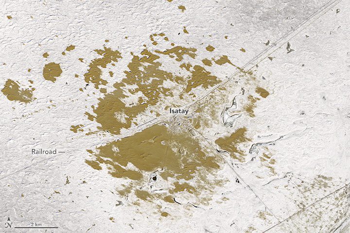
Shrub Could Save Kazakhstan Land
Looking down from space in winter, the patch of Earth around Isatay looks greenish brown: a misleading color. This remote part of Kazakhstan”a country with just 8 percent arable land”is far from verdant.
Canon U.S.A. Announces a New Approach to Premium-Quality InkJet Printing with Océ ProStream Series
MELVILLE, N.Y. — Building on a decade of experience in inkjet technology, Canon U.S.A, Inc., a leader in digital imaging solutions, today announced its new Océ ProStream series inkjet press, a solution designed to open up new business opportunities for commercial...
“Rocket: the Earth in Your Pocket” Selected by EARSC as the European Earth Observation Product of the Year
For the ï¬rst year, under the umbrella of the EU Framework Program for Research and Innovation ConnectinGEO project, the EARSC competition “European EO product of the year†rewarded a company which has developed the most innovative product integrating an element...
GeoSLAM Growth Continues With Two Senior Appointments
GeoSLAM, a market-leader in the provision of 3D SLAM-based handheld indoor mapping systems, has boosted its senior team with two new appointments. The company, based in Bingham, Nottinghamshire, UK, has welcomed Richard Betts as its new CEO and John Allan, as...
Maptitude 115th Congressional Districts with 2010/15 Census & ACS Demographics
NEWTON, MASSACHUSETTS (USA) - Caliper is excited to announce that 115th Congressional Districts data are now available for the entire USA. These are the most accurate boundaries available, reflecting our expertise in the field as the market leading redistricting...
Djibouti Chooses what3words as National Addressing System
February 2017 - what3words, the multi-award winning addressing system, has been adopted as an addressing standard by La Poste de Djibouti. Located in the Horn of Africa Republic of Djibouti is the fifth country in the world to accept 3 word addresses to improve its...
