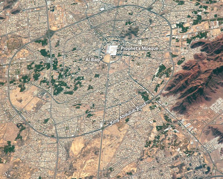
An astronaut aboard the International Space Station focused a high-resolution lens on the city of Medina (Madinah in official documents) in western Saudi Arabia.


An astronaut aboard the International Space Station focused a high-resolution lens on the city of Medina (Madinah in official documents) in western Saudi Arabia.
CHATTANOOGA, TN – Skytec LLC, a leading Unmanned Aircraft Systems (UAS) and Drone as a Service (DaaS) provider, has been selected to join the Esri Startup program as an emerging business partner. The three-year program is part of a global Esri initiative to...
SOUTH JORDAN, Utah- Nearmap, a location content provider, has partnered with the fast-growing city of Carmel, Indiana, helping it improve its stormwater billing process, resulting in the collection of about $60,000 in unclaimed revenue. Carmel turned to Nearmap to...
Cambridge, UK (www.1spatial.com) 1Spatial, the global geospatial software and solutions company, is pleased to announce that they have been awarded a contract from the European Union Satellite Centre (SatCen) in Torrejón de Ardoz (Madrid, Spain) to provide a solution...
Hallowell, Maine - Blue Marble Geographics (bluemarblegeo.com) is pleased to announce the availability of an update to the Global Mapper Academic Curriculum. Comprised of a series of hands-on lessons, the full package of lab materials is available free of charge to...
Kongsberg Geospatial, an Ottawa-based geospatial visualization software company, and SURVAE, a video and data mapping technology company based in Wilmington, NC, announced today that they have integrated the Kongsberg Geospatial IRIS UAS Ground Control Station (GCS)...
Redlands, California—Esri, the global leader in spatial analytics, and the United Nations Institute for Training and Research's (UNITAR) Operational Satellite Applications Programme (UNOSAT) will host the 2018 GIS for a Sustainable World conference from April 17...
MCLEAN, Va., April 09, 2018 - Iridium Communications Inc. (NASDAQ:IRDM) announced today that the Iridium-6/GRACE-FO rideshare mission, the sixth Iridium® NEXT launch overall, has been targeted for launch by SpaceX from Vandenberg Air Force Base (VAFB) in California...
DJI, the world’s leader in creative camera technology, has updated its Zenmuse X7 camera to support the new ProRes RAW standard from Apple. Enabled through firmware updates, the Zenmuse X7 also gains performance enhancements that deliver improved workflows and image...
CHICAGO -Â Cityzenith today announced the commercial launch of its much-awaited Smart World Pro 3D data platform, a new high-performance version of the company's flagship Smart World product for Architects and Property Owners. The "Digital Twin Data Platform of...