As Tropical Storm Bud was lashing parts of western Mexico and causing flooding that extended into the American Southwest, a tropical disturbance was spinning over the Gulf of Mexico and straddling southeastern Texas.
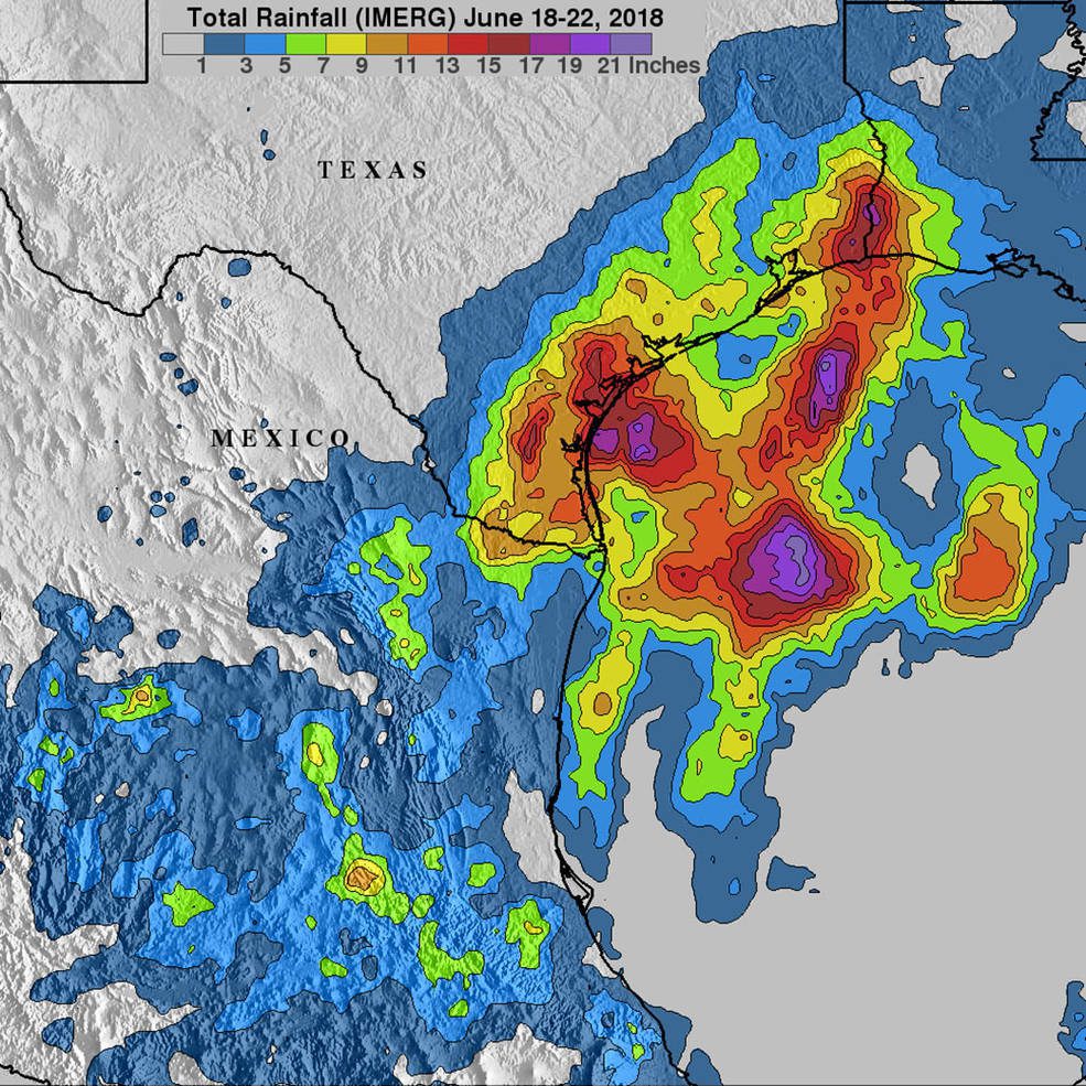
As Tropical Storm Bud was lashing parts of western Mexico and causing flooding that extended into the American Southwest, a tropical disturbance was spinning over the Gulf of Mexico and straddling southeastern Texas.
(Golden, Colorado) - The Women Presidents’ Organization (WPO), a peer advisory group for million dollar plus women-led companies, is proud to announce Blakelee Mills, CEO, Golden Software, LLC as the newest member of the Denver II Chapter of the WPO. “I am...
El Segundo, Calif. - Aerojet Rocketdyne is pleased to announce an expansion of its existing advanced engine development agreement with the Air Force’s Space and Missile Systems Center (SMC) to develop the upper-stage RL10C-X engine and continue the AR1 booster...
Dewberry’s Mount Laurel, New Jersey, office hosted its fourth annual survey merit badge day on June 3, 2018, for local members of the Boy Scouts of America. This is the fifth time employees across the company have organized the required exercises for the scouts to...
Israeli company IDAN Computers Ltd. uses the TatukGIS Developer Kernel to develop its ObliMapper aerial drone image capturing, handling, and analysis tool designed to efficiently combine the benefits of orthophotos with the rich detail of oblique imagery. ObliMapper...
NEWTON, MASSACHUSETTS (USA) - Point files with the locations for some of the largest U.S., Australia, Canada, and United Kingdom businesses are now downloadable for free for Maptitude 2018. The download includes point layers for automotive, bank, cellular phone,...
London – Telit, a global enabler of the Internet of Things (IoT), today announced the SE878Kx-A series of GPS and GNSS integrated antenna receiver modules for consumer and business applications that require high performance, maximum reliability and low power...
Leading Australian geospatial mapping technology company Soar has announced their highly anticipated Token Generation Event (TGE) designed to fund the launch of the world’s first decentralised global platform for the distribution of drone content and maps. The TGE...
REDLANDS, Calif.- Esri, the global leader in spatial analytics, today announced that it expects more than 18,000 mapping and GIS users at the San Diego Convention Center for its 38th Annual Esri User Conference (Esri UC), to be held July 9–13, 2018. The Esri UC is...
The American Institute of Certified Planners (AICP) is the American Planning Association's (APA) professional institute and provides the only nationwide, independent verification of planners' qualifications. Certified planners pledge to uphold high standards of...
