PALO ALTO, CA -Â SSL, a Maxar Technologies company (formerly MacDonald, Dettwiler and Associates Ltd.) (NYSE: MAXR) (TSX: MAXR), and a leading provider of innovative satellites and spacecraft systems, announced today the Merah Putih communications satellite built for...
Energy Web Atlas Launches World Pipeline Dataset
HOUSTON -Â Gulf Energy Information, a leading provider of market intelligence and technical information for the international energy industry, announced Tuesday the introduction of the World Pipeline layer to the Energy Web Atlas (EWA). Energy Web Atlas, an ESRI-based...
ACG Solutions and Critical Response Group Announce Strategic Business Relationship to Significantly Transform First Responder Emergency Operations
ATLANTA and EWING, N.J. -Â ACG Solutions (ACG), and Critical Response Group, Inc. (CRG) today announced the two companies have formed a strategic business relationship that will significantly enhance the first responder accuracy benefits of ACG's Synchronized...
Trimble RTX Correction Technology Now Delivers Two Centimeter Accuracy for a Broad Range of Positioning Applications
SUNNYVALE, Calif. - Trimble (NASDAQ: TRMB) announced today that its Trimble RTX™ GNSS corrections technology can now achieve horizontal accuracies of better than two centimeters. Start-up times, commonly referred to as convergence, have also improved. Users can...
DJI Partners With LINE FRIENDS For First Characterized Drone
SHENZHEN, China - DJI, the world's leader in civilian drones and aerial imaging technology, today announced a brand partnership with LINE FRIENDS on its first characterized drone, making drone technology more fun and accessible to a wider audience. Featuring one of...
TCarta Wins National Science Foundation Grant to Enhance Satellite-Derived Bathymetry Technology
DENVER, Colorado – TCarta Marine, a global provider of marine geospatial products, has been awarded a research and development grant by the National Science Foundation (NSF) to enhance and automate multiple techniques for deriving seafloor depth measurements from...

NOAA Report: 2017 Third-Warmest Year Ever
The year 2017 was the third-warmest on record for the globe, trailing 2016 and 2015, according to the 28th annual State of the Climate report. The planet also experienced record-high greenhouse gas concentrations as well as rises in sea level.
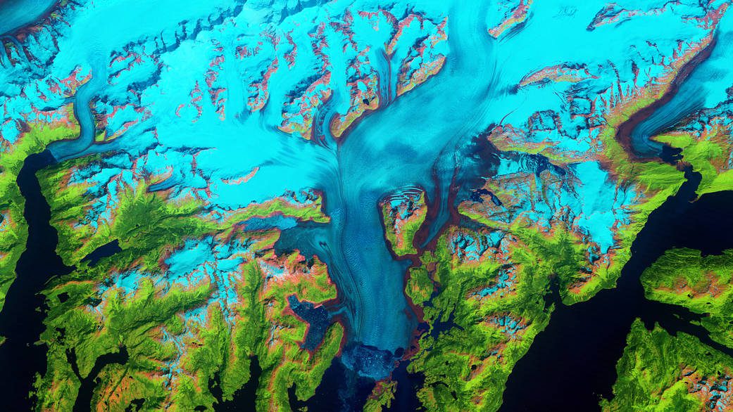
Columbia Glacier, Alaska
The Columbia Glacier descends from an ice field 10,000 feet (3,050 meters) above sea level, down the flanks of the Chugach Mountains, and into a narrow inlet that leads into Prince William Sound in southeastern Alaska.
Hexagon Expands Content Program to Increase Coverage and Access of Air-Borne Imagery
(WASHINGTON, D.C., Aug. 7, 2018) – Hexagon’s Geosystems Division, the smart digital realities provider, announced today updates for the 2018 airborne imagery collection plans of the Hexagon Imagery Program (HxIP), the premier source for professional airborne...
New FLIR InSite Mobile Application Simplifies Inspection Management
WILSONVILLE, Ore. – FLIR Systems, Inc. (NASDAQ: FLIR) announced today the launch of FLIR InSite™, a new mobile application and web portal for organizing client information and thermal inspection data in one location that is easy to access, manage, and share. Ideal...
