McLean, Virginia – Avineon, Inc. (Avineon), a global provider of information technology, geospatial, and engineering support services, is pleased to announce the acquisition of InfoGeographics, Inc. (IGI) located in Traverse City, Michigan. As a leading provider of...
Bluesky Uses Leica CityMapper to Capture Major UK Cities in 3D
Using the CityMapper, Bluesky was able to capture parts of London, Manchester and Birmingham as well as Brighton, Bristol, Cambridge, Norwich, Nottingham and Oxford. Bluesky intends to increase its coverage by capturing additional towns and cities across the UK and...
TerraSim® Demonstrates New Technology at I/ITSEC 2018
At I/ITSEC 2018 in Orlando, Florida, TerraSim will introduce our new terrain server technology which underpins BISim’s cloud-enabled simulation solution for the U.S. Army Synthetic Training Environment (STE) program. Our STE World Server (STEWS) is a geospatial data...
Quanergy Announces Partnership with LiDAR USA
SUNNYVALE, Calif. – Quanergy Systems, Inc., a global leader in the design and manufacture of LiDAR sensors and smart sensing solutions today announced a partnership with LiDAR USA, a distinguished provider of GIS, surveying, civil engineering, agriculture,...
Remote GeoSystems Adds MISB Full Motion Video (FMV) Support to LineVision Desktop
FORT COLLINS, Colorado, USA – Remote GeoSystems, Inc., a global provider of immersive geospatial video software and recorders for survey and inspection, is pleased to announce the LineVision™ Desktop software suite now supports map-based playback and geoProject™...
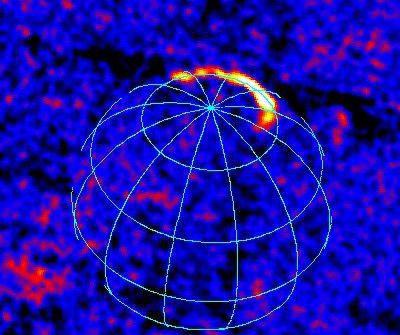
Integral X-Rays Earth's Aurora
Integral was initially preparing for astronomical research when it spied this aurora; the probe was planning to observe the skies at X-ray wavelengths to measure something known as the cosmic X-ray background, a diffuse level of radiation that pervades the cosmos and is linked to high-energy events such as black holes devouring nearby material in far-away galaxies.
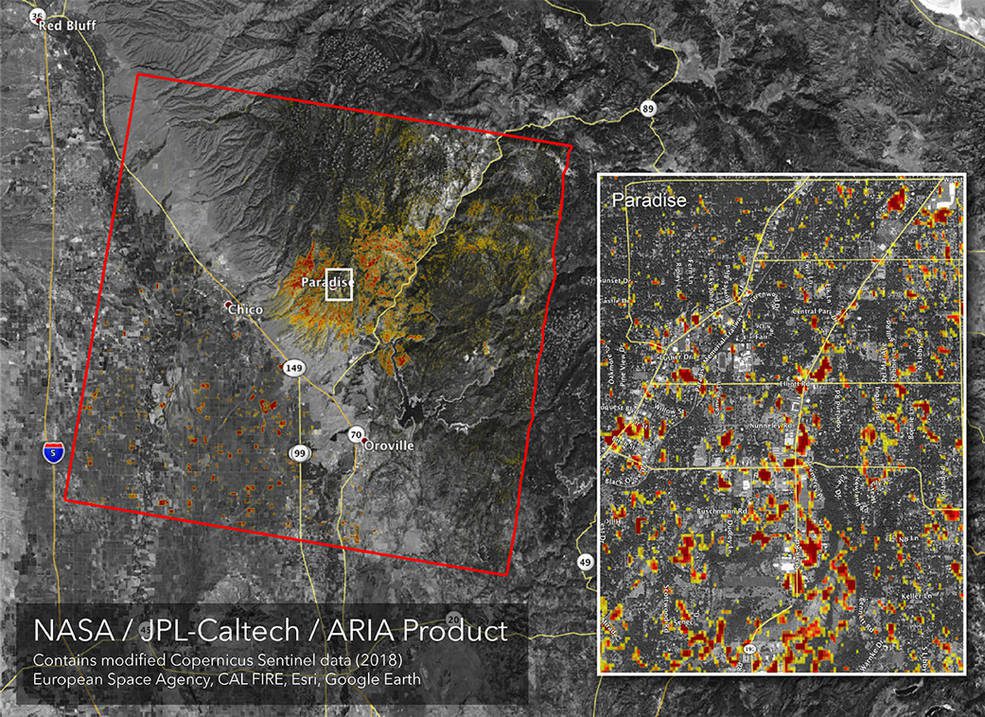
Updated NASA Damage Map of Camp Fire
As firefighters continue to battle the destructive Camp Fire in Northern California, the Advanced Rapid Imaging and Analysis (ARIA) team at NASA’s Jet Propulsion Laboratory in Pasadena, Calif., produced a new map showing damage as of Nov. 16., 2018.
LiDARUSA Announces Z+F Mobile Systems
LiDARUSA is pleased to announce the integration of the Z+F scanners for mobile mapping. The Z+F Profiler is a high-speed, very precise (sub mm), 360 deg scanner providing more than 1 million points/sec at up to 200 profiles/sec to a range of nearly 120 meters. Adding...
Cadcorp SIS 9 Released
Cadcorp, the UK based developer and supplier of GIS and web mapping software, has announced its latest release – Cadcorp SIS 9. The Cadcorp SIS suite of GIS products is a complete set of geospatial tools covering desktop, server, web, and application development...
City of Maple Ridge Recognized for Improving Community Engagement with GIS
VANCOUVER, Esri Canada User Conference – Esri Canada presented the City of Maple Ridge with an Award of Excellence for improving community engagement and collaboration using geographic information system (GIS) technology. Delivering on its commitment to Open...
