The Woolpert chief scientist and senior associate has been a trailblazer in lidar and remote sensing since the technology’s inception. DENVER — Dr. Qassim Abdullah, Ph.D., CP, PLS, was honored Tuesday night with the American Society for Photogrammetry and Remote...
East View Information Services Forms Alliance with the Center for Research Libraries to Digitize and Make Available 4.5 Million Pages of Newspaper Content
Minneapolis, MN USA— East View Information Services is pleased to announce a groundbreaking alliance with the Center for Research Libraries (CRL) to digitize and make available 4.5 million pages of international newspaper content. This initiative, part of the East...
Renesas Electronics Launches Digital Isolators with Superior Radiation Performance for Small Satellites in Low Earth Orbit
TOKYO, Japan – Renesas Electronics Corporation (TSE:6723), a premier supplier of advanced semiconductor solutions,today introduced two plastic packaged, radiation-tolerant digital isolators that provide the highest isolation protection (2,500VRMS) from high...
FARO® Releases SCENE 2019 for Advanced 3D Reality Capture
Lake Mary, FL — FARO® (NASDAQ:FARO), the world’s most trusted source for 3D measurement and imaging solutions for public safety forensics and construction BIM, announces the release of SCENE 2019, an advanced, integrated software platform that optimizes the FARO...
OGC Announces New Leadership
The Open Geospatial Consortium (OGC) proudly announces new Consortium leadership, effective 1 March 2019. Dr. Nadine Alameh returns to OGC to serve as OGC’s Chief Executive Officer (CEO). Nadine brings with her significant private sector executive leadership...
Esri Helps Government Agencies Meet New Open Data Law Requirements, Using ArcGIS Hub
REDLANDS, Calif. - Esri, the global leader in location intelligence, applauds the enactment of the federal Foundations for Evidence-Based Policymaking Act. Title II of this new law, the Open, Public, Electronic, and Necessary (OPEN) Government Data Act, sets a...
Geographic Enterprises Becomes a Map Business Online Value-Added Reseller
CORNISH, Maine - SpatialTEQ Inc., publisher of North America's most advanced business mapping software, today announces that Geographic Enterprises, LLC has accepted the role of authorized Value Added Reseller of www.MapBusinessOnline.com. Geographic Enterprises...
Esri Federal GIS Conference Spotlights the Future of Geospatial Infrastructure
REDLANDS, Calif. - Esri, the global leader in location intelligence, is hosting the twenty-second annual Esri Federal GIS Conference in Washington, DC. The gathering is an opportunity for government professionals to discuss best practices, participate in hands-on...
Ursa and SI Imaging Services Announce Further Collaboration on Satellite Analytics
ITHACA, N.Y.- Ursa Space Systems, Inc. (Ursa) and SI Imaging Services (SIIS) have signed a multi-year contract, establishing Ursa’s continued access to KOMPSAT 5 radar satellite imagery, distributed exclusively by SIIS. This contract renews a long-standing...
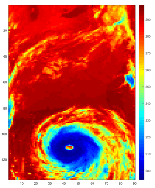
Warming Seas May Increase Frequency of Extreme Storms
A new NASA study shows that warming of the tropical oceans due to climate change could lead to a substantial increase in the frequency of extreme rain storms by the end of the century.
