SANTA CLARA, Calif.- Telenav®, Inc. (NASDAQ: TNAV), a leading provider of connected-car and location-based services, announced plans to accelerate its strategy to enable connected vehicles with location-based media and commerce through the transfer of assets...
MicroSurvey releases FieldGenius for Android
MicroSurvey Software, part of Hexagon, has released its new field data-collection software platform for Android users. FieldGenius for Android, version 1.0, is first release of the company’s new multi-platform field software built on the Android platform. It...
ManTech Acquires H2M Group to Expand Geospatial and Intelligence Analysis Capabilities
HERNDON, Va. - ManTech International Corporation (Nasdaq: MANT) has completed the acquisition of H2M Group (H2M), a leading provider of intelligence analysis services and solutions to primarily the National Geospatial-Intelligence Agency (NGA). Headquartered in...
New Book from Esri Illustrates How GIS Can Enrich Scientific Research
REDLANDS, Calif.- Esri, the global leader in location intelligence, today announced the publication of GIS for Science: Applying Mapping and Spatial Analytics. In their new book, Editors Dawn Wright and Christian Harder present examples of scientific research with...
Kratos Receives $4.8 Million in Sole Source Awards for High Performance Jet Drone Systems
SAN DIEGO - Kratos Defense & Security Solutions, Inc. (NASDAQ: KTOS), a leading National Security Solutions provider, announced today that its Unmanned Systems Division has recently received approximately $4.8 million of awards for high performance jet drones,...
Velodyne Lidar Announces Breakthrough Sensor for Autonomous Systems, Puck 32MRâ„¢
SAN JOSE, Calif.- Velodyne Lidar, Inc. today introduced the Puck 32MRâ„¢ sensor to address key markets in the autonomous industry. This product offers a cost-effective perception solution for low speed autonomous markets including industrial vehicles, robotics,...
NASA Invites Media to Drone Traffic Testing in Corpus Christi, Texas
As NASA continues the final stage of testing for its Unmanned Aircraft Systems Traffic Management (UTM) platform, the agency is inviting media to Corpus Christi, Texas, on Thursday, Aug. 15, to learn more about what it takes to fly drones safely in urban areas. This...
Esri Releases Green Infrastructure Planning Book
REDLANDS, Calif. - Esri, the global leader in location intelligence, today announced the publication of Green Infrastructure: Map and Plan the Natural World with GIS. The book offers a road map for planning communities whose design stresses the importance of humans...
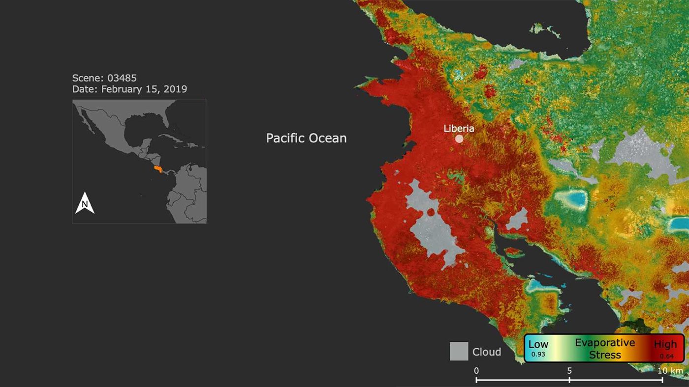
Plant Stress in Costa Rican Drought
NASA's ECOsystem Spaceborne Thermal Radiometer Experiment on Space Station (ECOSTRESS) imaged the stress on Costa Rican vegetation caused by a massive regional drought that led the Central American nation’s government to declare a state of emergency on July 23, 2019.

EDRS-C Successfully Launched
The second satellite to join the constellation that forms the European Data Relay System (EDRS) was successfully launched on Aug. 6, 2019, onboard an Ariane 5 rocket from Europe's Spaceport in Kourou, French Guiana.
