A new view of Hurricane Dorian shows the layers of the storm, as seen by an experimental NASA weather satellite that’s the size of a cereal box.
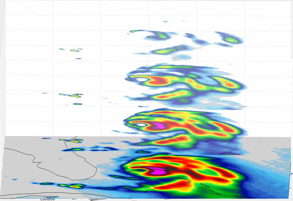
A new view of Hurricane Dorian shows the layers of the storm, as seen by an experimental NASA weather satellite that’s the size of a cereal box.
CAMBRIDGE, Mass.- NSR’s Satellite Manufacturing and Launch Services, 9th Edition report finds despite a few slow years, 1,155 satellites over 500 kg are expected to be ordered, with 1,285 to be launched, in the next decade. Between end of life replacement demand...
WASHINGTON - Flirtey, the pioneer of the commercial drone delivery industry, has unveiled the Flirtey Eagle, the world's most advanced drone delivery technology today with Senator Cortez Masto (D-NV) at The National Press Club in Washington, D.C. The company has...
UENOS AIRES – Satellogic, the world’s first vertically integrated geospatial analytics company, today announced that they have partnered with ABDAS, based in Henan Province, China, to deliver exclusive access to a dedicated constellation of satellites. The total...
NEW YORK - SiriusXM today announced the launch of its new Fish Mapping™ service. This new, comprehensive SiriusXM Marine package – designed to help saltwater anglers locate fish faster, as well as save time and fuel – is now available on the GXM 54 satellite...
SANTURCE, Puerto Rico- Red Cat Holdings, Inc. (OTC: RCAT), a leading provider of distributed data storage, analytics and services for the drone industry, today announced it has partnered with GoChain, a provider of scalable blockchain solutions for enterprises, NGOs...
SAN FRANCISCO and FRANKFURT, Germany - Swift Navigation, a San Francisco-based tech firm redefining Global Navigation Satellite System (GNSS) positioning technology for autonomous vehicles, today announced a partnership with Arm®, a global leader in semiconductor IP....
SAN JOSE, Calif. - Today, Cepton Technologies, Inc. announced its newest Vista lidar sensor, the VistaTM-X120, an industry-leading lidar solution for Advanced Driver Assistance Systems (ADAS) and autonomous applications. Vista-X120 offers a 120o horizontal field of...
The Copernicus satellite will now undergo extensive testing, with its launch set for November 2020 Friedrichshafen – Airbus has completed the ocean satellite ‘Copernicus Sentinel-6A’, and is now sending it on its first journey. Its destination: Ottobrunn...
The Open Geospatial Consortium (OGC) invites you to its next Location Powers summit, which will focus on Data Science. The event will be held at Google’s Crittenden Campus in Mountain View, CA on the 13th & 14th of November, 2019. At this summit, you will be...
