SAN DIEGO - Kratos Defense & Security Solutions, Inc. (Nasdaq:KTOS), a leading National Security Solutions provider, announced today that its Unmanned Systems Division has received a $3.6 million prime contract for capability expansion, mission system integration,...
Nevada holds Top Rating in Unmanned Aerial Systems (UAS) for Second Consecutive Year
RENO, Nev. - According to Business Facilities' 15th Annual Rankings: State Rankings Report (July/August 2019 Issue), the State of Nevada has maintained its #2 ranked Drone Industry position for a second consecutive year as a national leader in Unmanned Aerial Systems...
Flowfinity and Leica Geosystems Collaborate to Streamline High-Precision GNSS Data Collection Workflows
VANCOUVER, British Columbia - Flowfinity Wireless Inc. has today released new functionality that allows field users to collect highly precise GNSS location data via external Leica Zeno GG04 plus Smart Antennas in Flowfinity applications. This powerful new capability...
Hoverfly Awarded $10MM U.S. Government Contract for Tethered Drones
ORLANDO, Fla. - Hoverfly Technologies Inc. ("Hoverfly"), the manufacturer of the LiveSky tethered drone, announced today that it has been awarded a $10 million sole-source contract by a U.S. government agency. LiveSky provides aerial monitoring and communications...
Airbus and Sobloo announce finalists of Multi-Data Challenge within Copernicus Masters 2019
Toulouse – Airbus has unveiled the names of the three finalists for the “Airbus - Sobloo Multi-Data Challenge†organised as part of the Copernicus Masters 2019. This international competition awards pioneering solutions, concepts and ideas for industry and...
Latest Construction Field Software Uses Cloud Integration for More Efficient Workflow
(Heerbrugg, Switzerland, 9 October 2019) - Leica Geosystems, part of Hexagon, announced today a new software upgrade for Leica iCON field software as the first development under the collaboration with Procore, a leading provider of construction management software....

Ocean-Monitoring Satellite Mission Ends After 11 Successful Years
The Jason-2/Ocean Surface Topography Mission (OSTM), the third in a U.S.-European series of satellite missions designed to measure sea surface height, successfully ended its science mission on Oct. 1, 2019.
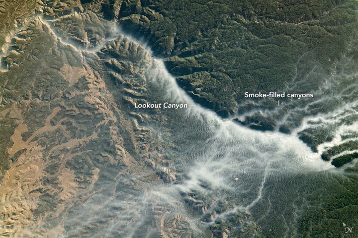
Smoke-Filled Canyons
An astronaut onboard the International Space Station shot this photograph of smoke-filled canyons.
HERE and HYUNDAI MNSOFT expand collaboration to advance global HD maps and location services
Amsterdam and Seoul – HERE Technologies, a global leader in mapping and location platform services, and HYUNDAI MNSOFT, a Hyundai Motor Group subsidiary specializing in mapping technology responsible for the Hyundai KIA Motors infotainment system, today announced...
Velodyne Lidar Executive Addresses How to Make Driverless Vehicles Safe, Ready and Familiar on the Road
SAN JOSE, Calif.- Dr. Mircea Gradu, Sr. Vice President Quality and Validation at Velodyne Lidar, Inc., will be featured on two panels at the upcoming GITEX Technology Week in Dubai on October 7 and 8. Gradu, a distinguished engineer, is an officer and the 2018...
