sensemetrics Inc., a California-based Industrial IoT (IIoT) and cloud technology company transforming sensor data into real-time business intelligence, today announced that Geosense, a leading UK manufacturer of geotechnical and structural monitoring instrumentation...
Matternet Partners with Robotic Skies for Global Unmanned Aircraft Maintenance Support
MOUNTAIN VIEW, Calif. - Matternet, a pioneer in drone delivery for medical applications, announced the company's partnership with Robotic Skies, a global maintenance network for commercial Unmanned Aircraft Systems (UAS), to provide field service and repair support...
Laser Technology, Inc., Redefines Data Collection with Hybrid Measurement Technology
Laser Technology, Inc., Redefines Data Collection with Hybrid Measurement Technology. Laser Technology, Inc., a manufacturing company specializing in laser speed, distance, and measurement devices, has announced the release of a new measurement tool within their...
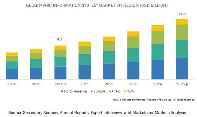
Geographic Information System Market Worth $14.5 Billion by 2025
A few key factors driving the growth of this market include the development of smart cities and urbanization, integration of geospatial technology with mainstream technologies for business intelligence, and the adoption of GIS solutions in the transportation sector.

Qarman CubeSat: Falling into a Fireball
While typical space missions resist orbital decay, Qarman will drift down month by month until it reenters the atmosphere, at which point it will gather a wealth of data on the fiery physics of reentry.
Leica Geosystems brings the world's first MultiStation to the next level
The new version of Leica Nova MS60 enables users to perform all surveying tasks with one instrument (Heerbrugg, Switzerland, 18 February 2020) – Leica Geosystems, part of Hexagon, announced today the new Leica Nova MS60. The MS60 MultiStation, brings sensor fusion...
Announcement of new dates for Geo Connect Asia
Southeast Asia’s inaugural geospatial event set to return on 24th-25th March 2021 Singapore – Following the cancellation of Geo Connect Asia 2020, in view of health and travel safety concerns connected to the still-evolving Covid-19 situation, organisers...
SoftServe Showcases Drone Innovation for Autonomous Firefighting at MBZIRC 2020 Robotics Challenge
AUSTIN, Texas - SoftServe, a leading digital authority and consulting company, will participate in the Mohamed Bin Zayed International Robotics Challenge (MBZIRC), a biennial international robotics competition, in collaboration with Czech Technical University to...
Enview Gains Momentum as Air Force Deploys AI Analytics for National Disaster Relief and Company Attracts Top Executive
SAN FRANCISCO -Â Enview, a leading 3D geospatial AI company, announced today that they have entered into a contract with the Air Force Research Laboratory (AFRL) to deploy Enview's AI analytics capabilities for use by the 60th Air Mobility Wing (60 AMW) to support...
Continental Mapping Adds Key Staff to Continue Strong Growth
Sun Prairie, WI – Continental Mapping, celebrating its 20th year in business, continues to support and fuel its ongoing growth by hiring numerous leaders in key positions throughout the company. These new staff bring leadership skills, broad industry exposure, a new...
