The cloud-based software and data portal groundMapper provides in-field mapping and analysis tools as well as instant access to specialist land and property datasets. Designed to improve project management, reporting and collaboration, Tilhill will also be drawing on...
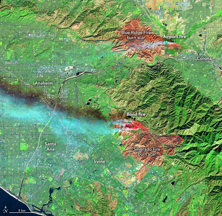
New Fires Scorch the Hills of Southern California
Fire season in California generally peaks from May through October. But as global temperatures have risen, so too has the state's risk for fall season fires.
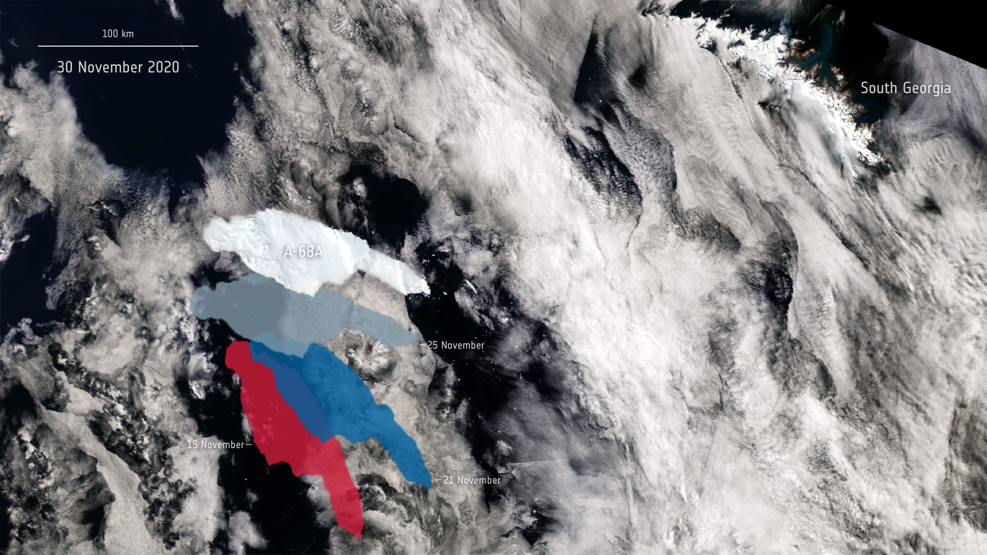
Iceberg on the Move
All eyes remain on the giant A-68A iceberg on its journey across the Southern Ocean. This image shows A-68A's movements using data from the Copernicus Sentinel-1 and Sentinel-3 missions.
Inpixon Enhances Enterprise-Class and Social Distancing Features with New Inpixon Mapping Release
PALO ALTO, Calif. and TORONTO - Inpixon (Nasdaq: INPX), the Indoor Intelligence™ company, today announced the release of its latest indoor mapping platform, Inpixon Mapping 4.14. This release introduces a new customer administration tool, SDK-based dynamic...
NuWave Solutions Acquires BigBear, a Leading Provider of Big Data Analytics Solutions to the National Security Community
WASHINGTON -Â NuWave Solutions ("NuWave"), a leading provider of data management, advanced analytics, artificial intelligence, cloud solutions and technologies to the federal government, announced today that it has acquired BigBear Inc. ("BigBear" or "the Company"), a...
Trimble and SiriusXM Establish Alliance to Deliver Trimble RTX GNSS Corrections via Satellite Radio for Autonomous Vehicles
SUNNYVALE, Calif. - Trimble (NASDAQ: TRMB) and Sirius XM Connected Vehicles Services Inc., a subsidiary of Sirius XM Holdings Inc. (NASDAQ: SIRI), announced today that Trimble RTX® GNSS corrections are being transmitted through the SiriusXM® satellite radio...
TomTom-Backed EU Initiative Delivers Road Safety Data Ecosystem
AMSTERDAM - Location technology specialist, TomTom (TOM2), today announced that its collaboration with the European Commission-backed Data for Road Safety initiative has resulted in a ready-to-deploy system to warn drivers about dangerous driving conditions....
AUC Woodruff Library Launches Website to Aid Disaster Response Organizations Statewide
ATLANTA -Â The Atlanta University Center Robert W. Woodruff Library received a LYRASIS Catalyst Fund grant in 2019 to create a publicly-editable directory of Georgia's Natural, Cultural and Historical Organizations (NCHs) to enable quick retrieval of critical location...
Kespry Announces Winter 2020 Aerial Intelligence Platform Release
MENLO PARK, Calif. -Â Kespry, the leader in visual and sensor-based data analytics, today announced its Winter 2020 Aerial Intelligence platform updates aimed at helping businesses across the mining, aggregates, energy, port, pulp and paper and insurance industries...
ONF Announces Aetherâ„¢ 5G Connected Edge Cloud Platform Being Used as the Software Platform for Pronto Project
MENLO PARK, Calif. - Today, the Open Networking Foundation (ONF) announced that ONF's Aether™ 5G Connected Edge Cloud platform is being used as the software platform for the $30M DARPA Pronto project, pursuing research to secure future 5G network infrastructure....
