UK-based Teledyne e2v’s Space Imaging group signs contract with aerospace, defence and security company Leonardo to supply a specialized image sensor for the Hyperspectral Imager HSI on-board the Copernicus Hyperspectral Imaging Mission for the Environment (CHIME)....
Virtual Surveyor Introduces Dropbox Integration for Easy Collaboration and File Access from Anywhere
AARSCHOT, Belgium, 6 April 2021 – Virtual Surveyor has introduced Dropbox integration in Version 8.0 of its popular drone surveying software. This means Virtual Surveyor users can now access their project files from anywhere while enjoying easy and affordable...
Amazon Web Services Becomes USGIF Strategic-Level Member
USGIF welcomes Amazon Web Services to its growing list of organizational members. Herndon, Virginia —The United States Geospatial Intelligence Foundation (USGIF) is pleased to welcome Amazon Web Services (AWS) as its newest Strategic-Level Member. AWS is the...
Knightscope Selects Velodyne Lidar Technology for Next-Generation Autonomous Security Solutions
MOUNTAIN VIEW, Calif.-Knightscope, Inc., a developer of advanced physical security technologies utilizing fully autonomous robots focused on enhancing U.S. security operations, and Velodyne Lidar, Inc., (NASDAQ: VLDR, VLDRW), jointly announced today that Knightscope...
Kratos Wins $86 Million, Assuming All Options Exercised, Single Award U.S. Army Contract for Drone Command and Control Systems
SAN DIEGO - Kratos Defense & Security Solutions, Inc. (NASDAQ: KTOS), a leading National Security Solutions provider and industry-leading provider of high-performance unmanned systems, today announced that Micro Systems, Inc., a wholly owned subsidiary of Kratos...
SkyTask, Inc. Announces FAA Waiver Approval for BVLOS Remote Flight Operations at Colorado State University Drone Center
DENVER -Remote UAV Flight Operations company SkyTask, Inc. announced today that it received its first FAA Waiver approvals for Beyond Visual Line Of Site (BVLOS) flight operations. Waivers Approved: FAA 14 CFR § 107.31 (Visual Line of Sight Aircraft Operation) FAA 14...
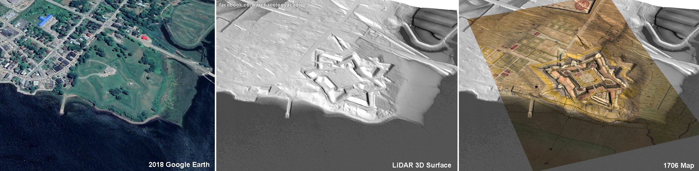
Archaeologist Brings 18th Century Fort to Life with LiDAR and 3D Modeling
A Canadian archaeologist is using advanced mapping and visualization technologies to bring one of the earliest European settlements in North America back to life.
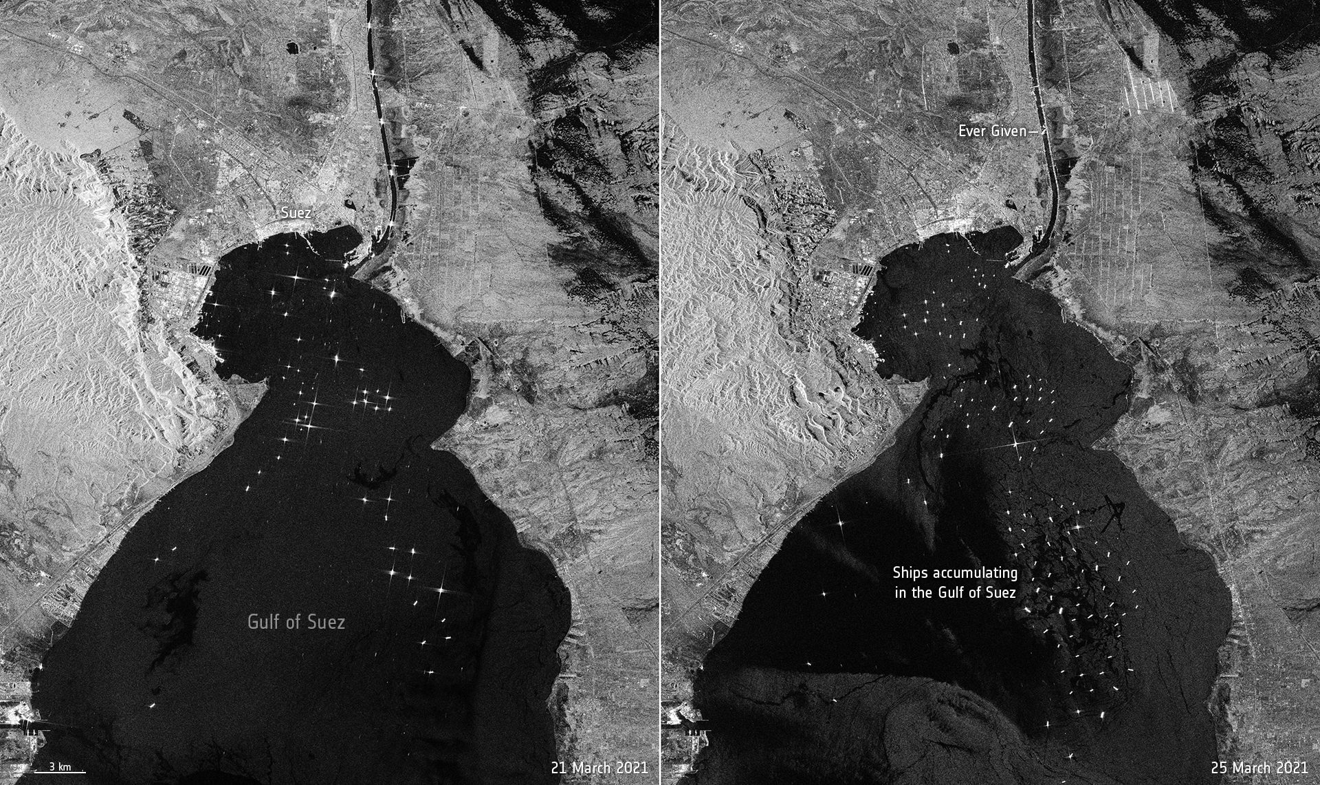
Suez Canal Traffic Jam Seen from Space
The enormous Ever Given container ship, wedged in Egypt's Suez Canal, is visible in images captured by the Copernicus Sentinel-1 mission.
Cesium Releases Free ‘Cesium for Unreal’ for All Creators
PHILADELPHIA - In collaboration with Epic Games, 3D geospatial software company Cesium has released Cesium for Unreal, a free, open source plugin that delivers high-resolution 3D geospatial technology and accurate real-world data for any type of application. ...
April GeoInnovation National Geospatial Speaker Series to Highlight Use of Geospatial Technology to Address Challenges During the Pandemic
Discussion will feature Dr. Este Geraghty, CMO of Esri, be moderated by Dr. Alexander Garza of St. Louis Metropolitan Pandemic Task Force  ST. LOUIS – How have health care experts used geospatial technology during the Covid-19 pandemic? What other ways is...
