GOLDEN, Colorado – Golden Software, a developer of affordable software for data visualization and analysis, has released Version 14 of the Grapher scientific graphing package with new plotting and customizing functionality. Available today, Grapher 14 is...
LaneAxis and DAV Network Partner with XYO to Eliminate Middlemen, Capture Rich Data for Transportation and Logistics Applications
SAN DIEGO - XYO (Kucoin: $XYO), the geospatial cryptonetwork, today announced partnerships with two leading organizations in the transportation and logistics space, DAV Network and LaneAxis. Each partnership will help drive the rapid growth and buildout of critical,...
Fortune Transportation Selects Trimble’s Video Intelligence to Improve Safety and Liability Protection
SUNNYVALE, Calif.- Trimble (NASDAQ: TRMB) announced that Fortune Transportation, a Minnesota-based refrigerated carrier, is deploying the Trimble® Video Intelligence™ solution in its 135 trucks. The Video Intelligence solution is designed specifically for the...
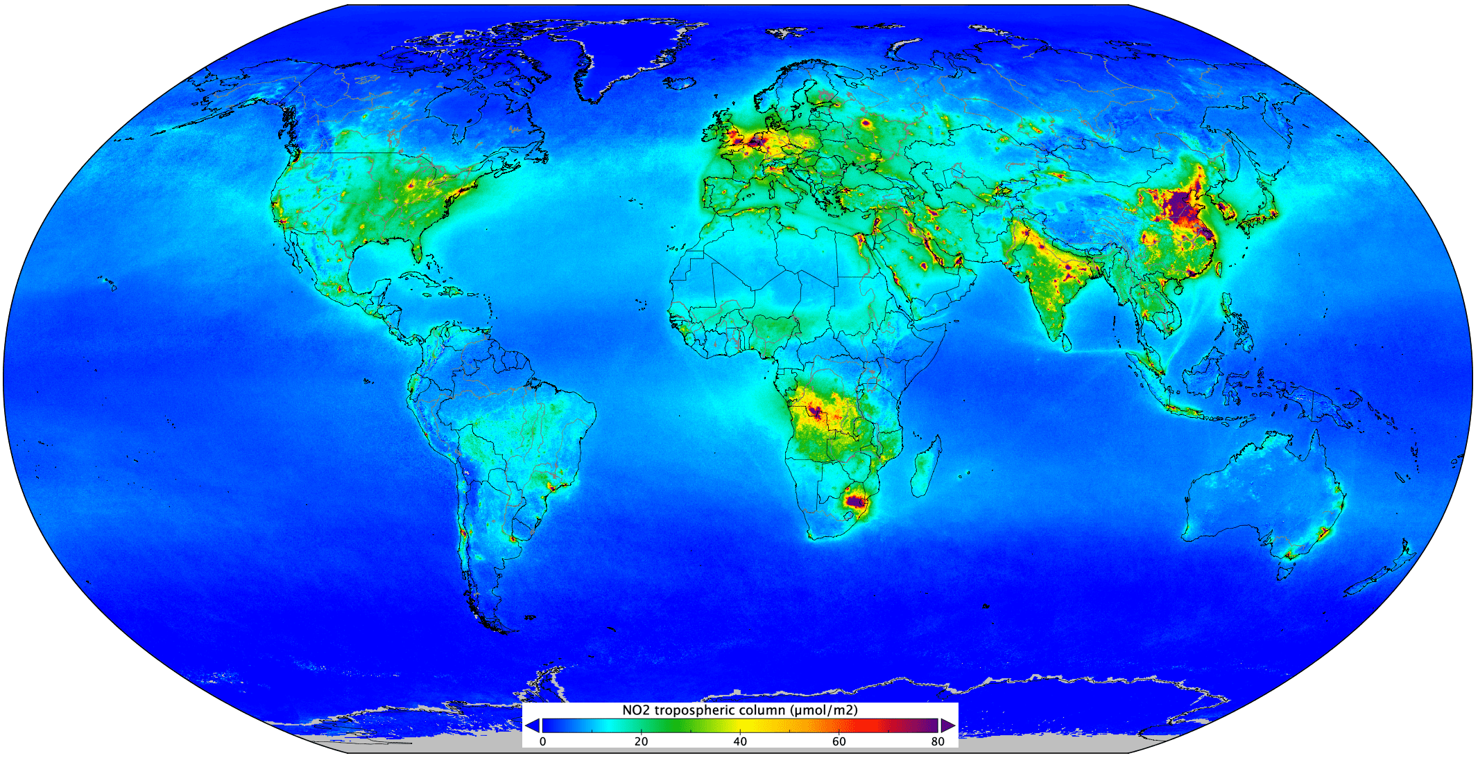
Nitrogen Dioxide Worldwide Pollution
Measurements gathered by the Copernicus Sentinel-5P mission between April and September 2018 have been averaged to reveal nitrogen dioxide in the atmosphere.
Esri Partners with 3LOG Systems to Bring the Power of Location Intelligence to Forestry Management
REDLANDS, Calif.- Esri, the global leader in location intelligence, today announced a partnership with 3LOG Systems, the makers of the preeminent log inventory management solution in the world forestry marketplace. Together, Esri and 3LOG will offer the...
Esri Recognizes Women's Contributions to GIS in New Book
REDLANDS, Calif.- Esri, the global leader in location intelligence, today announced the publication of Women and GIS: Mapping Their Stories. Throughout history, women have greatly enriched fields from science to education, leading research and directing decisions...
Flirtey and City of Reno receive FAA approval for drone delivery beyond visual line of sight
RENO, Nev.-Â Flirtey has received approval from the Federal Aviation Administration (FAA) to conduct drone delivery flights beyond visual line of sight (BVLOS), the City of Reno and Flirtey announced today. The new approval enables Flirtey to conduct drone delivery...
Esri Awards Schneider Electric for Exceptional Achievement
Fort Collins, Colo. – Schneider Electric, the industry leader in Geographic Information System (GIS) solutions for utilities and communication providers, was honored with the Delivering Release-Ready Solutions Award at the Esri Partner Conference held March 2-4...
TomTom and Elektrobit Reveal First HD Map Horizon for Automated Driving
GENEVA - TomTom (TOM2), the leading independent location technology specialist, and Elektrobit (EB), an award-winning global supplier of embedded and connected software products for the automotive industry, today announced the release of an industry-first High...
Bluesky and Getmapping Online Aerial Mapping for UK Public Sector
Leicestershire, UK – As part of the Aerial Photography for Great Britain (APGB) contract with the UK’s Geospatial Commission, Bluesky and Getmapping are providing free at the point of use Web Mapping Services (WMS) for qualifying local government organisations....
