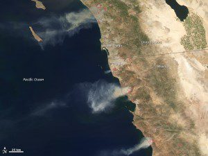
NASA's Aqua satellite detected several fires in San Diego County and the Baja California region of Mexico on May 14, 2014. Red outlines indicate hot spots where the satellite's MODIS sensor detected unusually warm surface temperatures associated with fires. Winds blew thick plumes of smoke west over the Pacific Ocean.
Record-breaking temperatures and powerful Santa Ana winds fueled at least nine fires in southern California and northwestern Mexico between May 14“16, 2014. Cal Fire estimated that by the morning of May 16, more than 19,000 acres (7,700 hectares) had burned, and news reports said that more than 100,000 people were forced to evacuate at various stages of the fires.
According to Cal Fire, the Pulgas fire had charred 8,000 acres and was just 5 percent contained by the morning of May 16. The Cocos/San Marcos fire had burned 3,018 acres and was 10 percent contained. The Tomahawk fire, which includes part of the U.S. Marines Camp Pendleton, had burned 6,300 acres and was 23 percent contained. More than 1,500 acres were consumed by the Bernardo fire, which was 90 percent contained.
Image courtesy of NASA.

