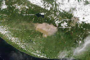
When Guatemala's Volcán de Fuego (Volcano of Fire) erupted on the morning of Sept. 13, 2012, NASA's Terra Earth observation satellite was high above to capture this natural-color image of the eruption as it occurred.
According to Guatemala's National Coordination for Disaster Reduction or ªCoordinadora Nacional para la Reducción de Desastres (CONRED), the eruption included ash emissions to the west and a 500-meter (2,000-foot) long lava flow. CONRED also warned of pyroclastic flows that could descend the mountain in any direction.
NASA image courtesy Jeff Schmaltz, LANCE/EOSDIS MODIS Rapid Response Team, GSFC.


