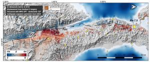
 Thematic experts from the Corinth Rift Laboratory in Greece generated a displacement map using Copernicus Sentinel-2 acquisitions from Sept. 17 and Oct. 2, showing the impact of the 7.5-magnitude earthquake that hit Indonesia on Sept. 28, 2018.
The earthquake and subsequent tsunami destroyed homes and are thought to have claimed at least 1,400 lives. It has been estimated that up to 1.5 million people will be affected by these events.
Photo Credit: Contains modified Copernicus Sentinel data (2018), processed by the Corinth Rift Laboratory

