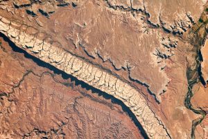
 The deserts of Utah offer many textbook examples of geologic exposures. Accented by dramatic shadows, this photograph shows canyons and prominent topography around Comb Ridge, as observed by an astronaut aboard the International Space Station (ISS). The town of Bluff, Utah, is one of the few human footprints on this southwestern U.S. landscape.
Comb Ridge (TséyÃkáán in Navajo) is a large example of a geologic formation known as a monocline. This type of structure occurs when previously flat rock layers fold downward in one direction and then flatten out away from the bend. This escarpment trends in the north-south direction for almost 80 miles (130 kilometers) from Utah's Abajo Mountains to Kayenta, Ariz. The Sun's position at mid-morning (local time) caused the jagged edges of the ridge to cast shadows that accentuate topography and add depth to the photo.
A mountain-building event known as the Laramide orogeny lifted up this area between 40 and 70 million years ago. Subsequent rivers and streams associated with Comb Wash helped erode away the lifted layers of rock, creating a steep relief along the western edge of the sandstone cliffs. Sharp-crested ridges formed by tilted rock layers and differential erosion are sometimes referred to as hogbacks by geologists due to the spine-like appearance of the outcrop. The hogback of Comb Ridge is composed of Navajo Sandstone, which stands in vivid contrast to the darker surrounding rock formations.
Image Credit: This astronaut photograph acquired on Aug. 20, 2019, is provided by the ISS Crew Earth Observations Facility and the Earth Science and Remote Sensing Unit, Johnson Space Center.

