By André Doumitt, CEO of Geosemble Technologies (http://www.geosemble.com/), El Segundo, Calif.
The Department of Homeland Security’s all-encompassing mission is “to prevent and deter terrorist attacks, protect against and respond to threats and hazards to the nation, and secure our national borders”. Such scope makes it clear that technology must play a central role in meeting that challenge. New sensing, monitoring, data integration and display technologies are among the primary drivers that will move homeland security forward. One benefit will be technology’s ability to free human resources from current time-consuming, labor-intensive “discover and integrate” activities to focus on the more critical “review and act” phases of threat identification and emergency response.
Remote sensing technologies already contribute enhanced data to the solution. Further, the maturation of today’s satellite, aircraft and land-based systems are providing sophisticated imagery on critical infrastructure and fast-moving storms. Earth observation satellites with thermal infrared (IR) sensors”combined with aircraft- and land-based Doppler radar”track, analyze and predict hurricane behavior with amazing accuracy.
For example, to understand the potential threats of a hurricane, scientists developed the Sea, Lake and Overland Surges from Hurricanes (SLOSH) model. The National Hurricane Center (NHC) uses this computerized model to estimate anticipated storm surge heights and wind velocities. Historical, hypothetical or predicted hurricanes are modeled, taking into account an active hurricane’s pressure, size, forward speed, track and other factors. The system aggregates such data to predict events such as the potential maximum storm surge flooding for a given geographic area. SLOSH’s predictive capabilities point toward tomorrow’s even more technologically sophisticated emergency response solutions.
Overcoming Initial Challenges
One challenge has been the geographic data Tower of Babel in which various state and local agencies hold their own data, with little interagency access or interoperability. Federal agencies have difficulty coordinating within themselves and among each other. In a natural disaster scenario, for example, it may be difficult to determine what assets are at risk. The dynamic picture on the ground isn’t always known on a timely basis. The same holds true for a terrorist incident management scenario in which critical utility, power, airport or military facilities may be at risk. Fragmented data make it difficult to assemble a clear picture of the asset distribution and make-up in a given geographic site.

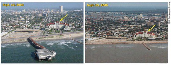
Remote sensing data contribute to a wide array of change-detection applications. Here two oblique aerial photographs show Galvestion, Texas, before (left) and after (right) Hurricane Ike made landfall. Yellow arrows mark features that appear in each image. Hurricane-induced waves and surge destroyed a pier and eroaded adjacent beaches.
For example, according to a Federal Emergency Management Agency (FEMA) report, when Hurricane Isabel slammed into the eastern seaboard in 2003, the Delaware interagency response team had little coordinated access to even commonly available geographic information. Each office had to develop its own geographic data and maps. These duplicated efforts caused confusion and contributed to an inefficient rescue effort.
Similarly, following the World Trade Center attacks, response teams initially had to work with building-footprint data digitized from a tourist map. It took several days to locate a floor plan. Eventually, three different floor-plan datasets emerged from three sources, requiring more time to evaluate and settle on one.
Progress Will Trigger More Sophisticated Technology
Fortunately, there has been great progress in integrating data across and within government agencies. The Homeland Security Infrastructure Program is a leader with its network of some 17 federal agencies,
numerous state/local participants and several private companies. Collectively pooling and integrating geographic data points is creating a viable foundation-level national database.
Such massive databases will trigger the need for robust applications that are smart enough to assimilate and analyze all that information. Human analysis, already a daunting task as the volume of data expands, will be replaced with “smart” computer applications that “think”. The future points to artificial intelligence (AI)”automated systems that turn vast databases into actionable scenarios, such as telling emergency response personnel what’s where, what’s relevant and what’s new. Humans will concentrate on the integrated picture an AI-based application displays and be able to act on it in a timely manner.
The Future Is Just Around the Corner
As hurricanes threaten populated areas, a smart system will visualize on maps and/or satellite images the threats to residents, structures, protected wetlands, emergency routes, etc., in ways that accelerate assessments and rapid-response decisions. AI already has gained acceptance for its ability to perform complex analytics of multidimensional data, especially in the finance industries. Algorithms, the heart of AI systems, extract, analyze and integrate information that would take days for an armada of humans to perform.
Already applied AI has proved its ability to ingest raw information from diverse sources such as online RSS feeds and Web sites (even tweets), online and offline databases, phone number lists, census data, personnel rosters, commercial building occupants and more. In practice, emergency response personnel tasked with protecting a critical structure could do so by simply configuring an AI system as follows: “Monitor these 50 Web sites where sensors or humans may post relevant reports, and display all content, including police and other named investigative/law enforcement feeds, containing these nine keywords. Display any alerts issued about activities within one mile of this structure, then send e-mail to my Blackberry and auto-summarize any content containing more than 50 words.” The number of information sources, queries and responses can extend well beyond this limited example. Thus, technology can create the conditions for positively impacting the mitigation, preparedness, response and recovery of emergency situations that emerge from threat events.
Tomorrow’s Department of Homeland Security will be empowered by employing the technology that lets us know more sooner, which translates into more efficient predictions. The day may come when taking preventative action in emergencies, whether in response to natural or man-made situations, becomes practical. The path to such success includes many challenges, but intelligent data integration hold the real promise of delivering security against natural threats and hazards.


