Building an operative offshore emergency response capability for oil and gas operations requires the right combination of tools to ensure effective decisions are made during the critical first 24-48 hours of an event.
By Paul Kennedy, MDA Geospatial Services Inc. (www.mdacorporation.com), Richmond, British Columbia, Canada.
Since the 2010 Macondo incident in the Gulf of Mexico, offshore emergency response procedures and preparedness have evolved quickly. In parallel, remote monitoring technologies and operational approaches to satellite data use also have advanced. However, such developments have occurred largely independently of oil and gas (O&G) operations. Today, there's a growing convergence among emergency response needs and activities, emergency preparedness, and remote monitoring tools and capabilities to serve offshore oil and
gas operations.
A consistent factor in many recent emergency response case studies”oil spills, hurricane response and others”is the difficulty of integrating new information streams into response operations quickly enough for the information to be useful. The old approach of turning on a flood of remote sensing and other data at the onset of an offshore incident doesn't provide adequate value to front-line emergency response teams nor to the management and regulatory teams directing and appraising response effectiveness.
Satellite Support
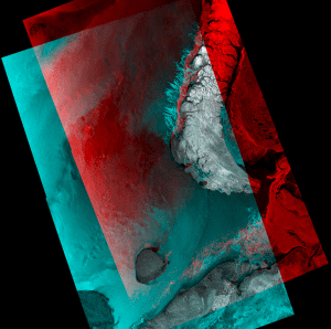
MDA's Arctic operations support services provide broad-area ice mapping and information products to support safe, efficient Arctic activity.
Remote sensing satellites can be split into two general groups”those that carry passive or optical sensors, which depend on illumination from the sun to capture images, and those that carry active sensors, such as synthetic aperture radar (SAR), which emit energy pulses and capture the returned signals to form images of Earth's surface.
Optical sensors are powerful information sources but are constrained by daylight, cloud cover and ambient-lighting conditions. The benefits of incorporating SAR imagery into monitoring programs include day and night all-weather imaging; proven success detecting, delineating and tracking oil on water; wide-area coverage; and rapid data-acquisition tasking. Based on these strengths, the use of imagery from SAR satellites is a critical component of operational monitoring programs for emergency preparedness and response.
The Arctic Operations Challenge
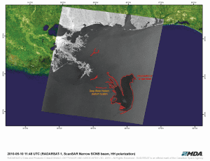
The MDA Oil Tracker service's broad-area coverage and rapid information delivery supported emergency preparedness monitoring and incident response coordination during the 2010 Deepwater Horizon oil rig disaster in the Gulf Coast.
Human activity in the Arctic has increased dramatically during the last decade, notably for O&G exploration, transportation, tourism and fishing. Increased demand for petroleum products from emerging markets has shifted the exploration focus from traditional regions to the Arctic and its increasingly accessible seas.
Committing to O&G exploration and production operations in the Arctic brings a unique set of challenges to operators. The
remote location, climate, maritime conditions and fragility of the ecosystem are unlike any other place on Earth. Reliable communications, computer networks, satellite coverage, supply chains, situational awareness, navigation and emergency response contingencies present unique problems and challenges to overcome.
Multisatellite Monitoring
Oil exploration and production is challenging in remote areas, as there's restricted access to shore-based response teams, infrastructure and broadband communications. As a result, having rapid, accurate broad-area situational awareness information is key to successful emergency response. At the core of situational awareness is ready access to dependable information and a clear understanding of the tools and procedures necessary to maintain safe operations and, when required, respond to emergencies.
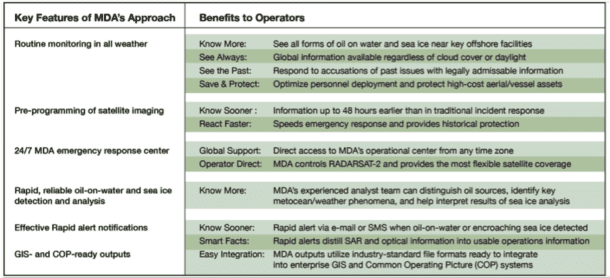
MDA provides easy access to near real-time satellite data information anywhere in the world to optimize emergency response and support.
Satellite-based SAR sensors support offshore O&G activities by providing wide-area, high-frequency, all-weather day and night coverage of land and maritime areas and delivering accurate, reliable navigation support and environmental reporting. Integrating multiple data sources into operational information workflows enables users to build on the strengths and revisit capabilities of such sensors.
For example, Canada's RADARSAT-2 SAR satellite, as well as the next-generation RADARSAT Constellation Mission, which will comprise three identical satellites launched in 2018, offers operational reliability, rapid tasking and broad-area coverage in maritime-friendly C-Band radar. Built and operated by MDA, RADARSAT-2 is central to planning and operations support at high latitudes and provides global coverage for a range of applications, from monitoring wide-area blue water, pack ice and sea ice to littoral navigation. The near real-time health, safety and environment (HSE) information provided by SAR satellites is a valuable component of a comprehensive emergency response plan.
Building Situational Awareness
All-weather situational awareness for offshore operations must incorporate oil-on-water information, vessel-traffic updates, sea-ice movement (where applicable) and metocean conditions. When all of those elements”from satellite, aerial and vessel sensors”are integrated into response models for rehearsals, and then used in a real emergency as known factors, action can be taken to safely and efficiently mitigate risks to personnel and the environment.
The success of emergency response
efforts during an oil-on-water event depends on the rapid delivery of multi-faceted surveillance and its integration into existing information systems. Historically, the critical first 24-48 hours of an event have been devoted to gathering basic data and incorporating the data into systems to assist in deploying incident response resources. Without a broad situational overview,
monitoring from targeted local assets such as helicopters, planes and vessels can be delayed or even misdirected, and the size and shape of a slick and its trajectory remain unknown.
Health and safety protocols inherent in the offshore industry seek to limit the risks to people working on an oil spill. Exclusion zones to keep personnel and assets out of potentially explosive environments can further restrict access. Timely, accurate information leads to a clear understanding of all aspects of an operating environment as well as the rapid development and deployment of a safe, effective response effort.
For example, MDA delivers a common operating picture (COP) capability that is operationally proven, secure and easy to use, integrating satellite, aerial and in-situ sensor data with live automatic identification system (AIS) data streams from maritime vessels, navigation charts, base mapping and planning information. Key differentiators in delivering information quickly include MDA's global network of multisatellite ground stations, 24/7 operations and the ability to rapidly program satellite acquisitions over areas of interest for emergency requests.
Developing a COP demands continuous updates and information dissemination that allows on- and off-scene personnel to share the same information about an incident, including the availability and location of resources and personnel as well as the status of assistance requests. A COP offers an incident overview that enables operators, supporting agencies and organizations engaged in the response effort to make effective, consistent and timely decisions.
From the outset, an oil-on-water or sea-ice incident response requires information needed to begin building a COP and in turn adds logistical, contractual and technical tasks to a challenging mobilization period. Delays in accessing and merging critical data streams, filtering data into information and disseminating the results across a wide user base in such circumstances typically leads to a less-efficient response with the potential for increased environmental and financial consequences.
To address these challenges, MDA provides easy access to near real-time satellite data information anywhere in the world with COPs for areas of interest, combined with remote monitoring capabilities that form the basis for planning and response training before an incident occurs. To save time, money and communication satellite bandwidth, as well as optimize user workflows, MDA extracts and delivers appropriate information for the situation, rather than providing high-resolution imagery or complex data streams where they don't provide benefit.
Incident readiness includes familiarity with information streams and how they come together and can be multipurposed. MDA's solution builds cost-effective situational awareness for security and health, safety and environmental requirements using metocean and weather support as well as imagery archives to support regulatory and legal issues. By integrating a COP into routine operations, such an approach builds familiarity with data and tools, improving response time and incident operations.
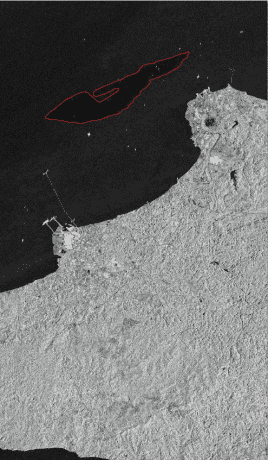
Proactively identifying operational oil spills, natural seeps and bilge dumping mitigates risk and minimizes downtime.
MDA works closely with London-based Oil Spill Response Limited (www.oilspillresponse.com) to improve satellite surveillance of oil spills and create an integrated service that combines satellite information with aerial and in-situ data to simplify contracting and activation of near real-time satellite monitoring. The intention is to combine the required information, processes, training and infrastructure into regular operations so responders are familiar with available resources and ready for an emergency situation. A clear process and structure underpins the success of any emergency response and remediation effort.
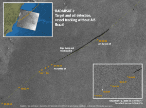
MDA Oil Tracker Online integrates satellite monitoring with aerial surveillance, infrastructure, AIS ship locations, and local first-responder data to give a complete view of the maritime environment and response activities.
Situational awareness from a COP is vital during the first 24 hours of an incident, as it improves the accuracy of spill assessments and affected areas while increasing the operational effectiveness of early response efforts through improved understanding and communication. The key is to simplify data collection, analysis and workflow. With familiar data, known tools and a standardized ordering process, emergency responders better understand their capabilities and limitations. With information sharing and support tools in place, key personnel can be trained to maximize their power, resulting in more effective resource deployment and better decision-making processes.

