The U.S. Geological Survey's Emergency Operations Office gives emergency managers fast access to critical satellite imagery.
By Kevin P. Corbley, principal, Corbley Communications (www.corbleycommunications.com), Castle Rock, Colo., and John Stenmark, principal, Genesee Communications (www.geneseecomms.com), Golden, Colo.
The use of geographic information system (GIS) technology is gaining widespread acceptance in the disaster response and management community. Emergency managers useGISfor preparedness, as well as for event management and follow up. Pre-incidentGISinformation includes location and status of critical infrastructure and emergency services, as well as identifying areas susceptible to damage. During an event, up-to-dateGISinformation helps emergency managers deploy and prioritize the use of assets. As efforts move into recovery and rebuilding,GIStechnology continues to assist in damage assessment, construction planning and mitigation of future incidents.

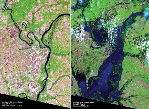
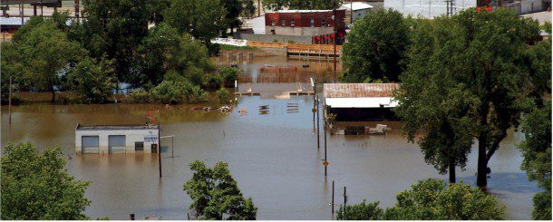
Mississippi River floods in April and May 2011 were among the largest and most damaging recorded along the U.S. waterway in the last century. HDDS delivered remotely sensed images that showed precisely which areas were impacted. Since the beginning of 2011, HDDS has distributed more than 18TB (nearly 3 million files) to the disaster response community.
Every GIShas an enormous appetite for geographic data, especially up-to-date maps and images. Satellite and airborne remote sensing plays an important role in providing both pre- and post-incident imagery. Although there exists a large array of government and private imaging sources for information, finding and obtaining the needed imagery in a short time frame”as is usually the case in an emergency situation”can become a daunting task forGIS operators.
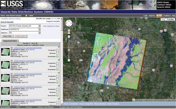
In response to the need, the U.S. Geological Survey (USGS) National Geospatial Program and Land Remote Sensing Program established the Emergency Operations (EO) Office. As part of its EO support, USGS participates in the International Charter for Space and Major Disasters. Some EO resources are located at the USGS Earth Resources Observation and Science (EROS) Center in Sioux Falls, S.D. They support the Hazard Data Distribution System (HDDS), which is used to acquire and deliver satellite and aerial imagery. During natural or human-caused disasters, the web-based HDDS portal provides archived and new imagery free to emergency response personnel.
Our objective is to provide coordination and support on geospatial information activities associated with emergency response to disasters, says Brenda Jones, USGS disaster response coordinator. At EROS, we can handle a lot of requests for data downloads. We collect imagery from different agencies and groups, and disseminate it on the HDDS.

HDDS provides data access and delivery services through graphic and traditional directory-based interfaces that allow emergency response personnel to select and obtain pre-event baseline and post-event emergency response imagery.
Use of the HDDS portal is open to all U.S. emergency management officials at the federal, state and local levels. To optimize performance during an emergency, USGS strongly recommends that emergency managers become familiar with the HDDS site and its capabilities before a disaster strikes their region.
GIS Bolsters Midwest Flood Response
AlthoughGIStechnology has been around for decades, it's still fairly new in the emergency management arena. Although it accelerated in the wake of 9/11, Hurricane Katrina and the Indonesian tsunami in 2004, it was the flooding across the U.S. Midwest in 2008 that broughtGISapplications for image data to the fore.
During or immediately after a disaster, a satellite image or aerial photo is usually the quickest and most efficient way to determine the scope and severity of the event. Remotely sensed images show precisely which areas were impacted and often reveal the hardest hit sites. In many cases, imagery becomes the most up-to-date map available, showing vital information such as which routes to the area are accessible and which are blocked.

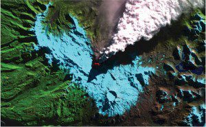
HDDS can be used to view and download USGS datasets for national and international disasters. Here a Landsat Thematic Mapper image reveals ongoing volcanic activity after an eruption occurred on June 4, 2011, in Chile's Puyehue-Cordón Caulle volcanic complex.
According to Chris Diller,GIScoordinator for the Wisconsin Department of Military Affairs (WDMA), which includes the state's Division of Emergency Management, WDMA first usedGISin August 2007 to support emergency operations for local flooding. The experience helped the department prepare to use the USGS system when the floods returned the following year.
The 2007 incident allowed us to make sure that we had our entireGISinfrastructure in order and that we had all of our protocols established, he explains.
Diller said the USGS coordination enabled him to obtain several different types of imagery. WDMA overlaid image information from the U.S. Landsat, FrenchSPOTand Canadian RADARSAT satellites with aerial photos taken in both visible and infrared bands.
The interesting thing about the satellite sensors is that each of them identified small pockets of water that the other sensors did not pick up, he says. I thought theSPOTdata would have showed the things that RADARSAT and Landsat had already covered, but that wasn't the case. The multiple sensors were complementary.
In areas where aerial photos were available, Diller overlaid the satellite imagery with aerial data to provide a ground truth check. That verification helped the team process images of other affected regions.
In Indiana, Ashlee Moore, aGISplanner for the state's Department of Homeland Security, worked with USGS to obtain imagery for flooding during the 2008 incidents. SaysMoore, We received Landsat images directly from USGS andSPOTand other data from different space agencies via the charter (see The International Charter on Space and Major Disasters, page 24). USGS facilitated things with the charter, and we were able to use the maximum amount of data.
USGS Anchors Emergency Operations
USGS is set up to provide a broad array of information to emergency managers, and Jones describes her role as that of a facilitator and liaison. USGS provides data directly from Landsat and NASA's EO-1 satellite, and receives other satellite information from the U.S. National Geospatial-Intelligence Agency, the Air Force and the charter. For aerial photography, Jones draws from a variety of resources, including the USGS Land Remote Sensing Program, the Federal Emergency Management Agency, the Civil Air Patrol, the National Oceanic and Atmospheric Administration, the Department of Agriculture and the Department of Defense.
Public-domain satellite imagery from sources such as Landsat, ASTER and EO-1 are posted to a public site on HDDS. Commercial imagery such as QuickBird, IKONOS orSPOTis licensed and goes to an HDDS site with restricted access. But even the licensed information is free for emergency managers.
Imagery collected at FEMA's request to support the federal mission is generally shared for free with state, tribal or local governments. Additional imagery necessary to support state, tribal or local government requirements may be acquired through a cost-share arrangement.
Ensuring What's Needed Is Available
For Jones, it's all about knowing what information is available and how to get it. She says the selection of resources depends on the magnitude of the event and the type of information needed. Satellite passes rarely coincide perfectly with disaster events, and smoke or weather can hamper visual observation.GISmanagers working on emergency response rarely have time to determine the best sources. Therefore, the Department of Homeland Security has formed the Interagency Remote Sensing Coordination Cell, which helps to fill the gap by identifying the most suitable sources and managing the flow of data to responders on the ground.
According to Diller, getting imagery from the USGS system was straightforward. I defined the areas for which we needed imagery, he says. That was coordinated with USGS, which helped us identify the products we needed. Once we asked for that imagery, orders went onto the [acquisition] schedules. As the imagery was scheduled and collected, we were getting daily updates from USGS on acquisition schedules, satellite paths and other information on when data would be collected.
During the floods in Indiana, Moore said they began to receive imagery soon after the initial requests. As the flooding moved downstream, she could issue additional requests to cover the extents of the affected areas.
If everything went smoothly, we would receive data in 48 hours, she says. There were times that it took a few days to get imagery. It just depends on what the situation is with the satellites. USGS is a great partner and did a good job in keeping us aware of what was going on.
During large disasters, the USGS EO Office, to support broader federal response efforts, hosts a telecommittee called the Remote Sensing Working Group. The group conducts daily conference calls about remote sensing requirements and issues related to the disaster. We don't do it all the time, explains Jones, but we will do it anytime a federal, state or local agency requests it. Then we get all the players on board. It's more of a community now than it was four or five years ago.
Although things move quickly during an incident, much of aGIS's value comes from information put into place prior to a disaster. To provide teams with baseline information, Jones accesses the U.S. Department of Agriculture's National Agricultural Imagery Program to collect pre-event aerial photography, along with historical Landsat data from the USGS archive in Sioux Falls. Beyond the image data, vector layers may be available for some locations, including elevation data, transportation, emergency services and cadastral information.
By the end of 2008, Diller had completed a county-by-county map atlas and statistics of the inundated areas in Wisconsin. There are quite a variety of people who want to use the information, he says. Agencies that needed information during the flooding are continuing to use it for recovery purposes, as well as mitigation against future floods. It's helping to identify and assist businesses that were affected by the floods. And the Department of Natural Resources will use it to modernize floodplains. The value of the imagery and data supplied to us has paid benefits over and over again.
Getting Connected with HDDS
Moore and Diller described their first experiences with HDDS as training on the fly. Although both were aware of HDDS and the charter prior to the floods, they hadn't completed formal training for the programs when the emergencies hit. Jones stresses that responders will benefit by getting in contact with her before urgent needs arise. The pre-disaster conversations give responders a clear idea of what to expect during a crisis.
Sometimes expectations don't necessarily jibe with the reality of the situation, she says. We can do a lot, but it's difficult to meet everyone's requirements. I really encourage people who are interested in using this to make contact before something happens.
As part of its outreach program, the USGS EO unit provides training on HDDS resources and services, as well as information on how responder agencies can use the charter. The HDDS website is available to the public at http://hdds.usgs.gov. Initial contact to the USGS EO Office can be made by emailing [email protected].
The International Charter on Space and Major Disasters
USGS plays a key role in the United States and around the world.
The International Charter on Space and Major Disasters was established in 1999 by the European and French space agencies (ESAand CNES). The charter's objective is to use space-based assets to contribute to managing natural or technological disasters. By 2007, the charter had grown to include government and commercial satellite operators in Canada, Argentina, Japan, the United States, the United Kingdom and China. The U.S. Geological Survey (USGS) entered the Charter in 2005, joining the National Oceanic and Atmospheric Administration as part of the U.S. team already in place.
Through its members, the charter provides access to a variety of space-based imaging and remote sensing systems. Emergency managers use defined processes to activate the charter and receive information. For each activation, the charter assigns a project manager to handle requests and ensure accurate information is delivered to the users. In a typical year, the charter is activated more than 20 times around the world. It's important to note the charter need not be invoked for the USGS Emergency Operations Program to respond to a local event in the United States.
 USGS acts as the link to the charter in the United States. As situations develop, the USGS team can use charter provisions to provide imagery to local responders. The charter views USGS and Landsat data as important resources for its participants. Landsat data are very good for base maps in areas where they don't have any maps, explains USGS Disaster Response Coordinator Brenda


