Fusing LiDAR's 3-D feature and elevation data with geospatialimagery creates powerful and accurate mapping applications.
By Cherie Darnel, senior technical solutions engineer, Exelis Visual Information Solutions (www.exelisvis.com), Boulder, Colo.
Light detection and ranging (LiDAR) technology is a growing source of detailed 3-D elevation data that can provide meaningful context about geographic areas. By adding LiDAR data to existing geospatial image analysis workflows, users have the ability to create a more complete visual reference for the geographic areas they analyze. And, as LiDAR data become more available and LiDAR data analysis software technologies become more advanced, additional detailed 3-D feature and elevation information can help solve complex problems.

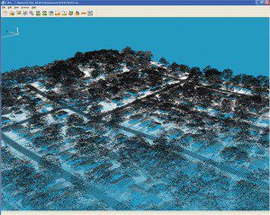
LiDAR datasets are delivered in a point cloud, which is a collection of data points that are plotted on three axes, giving the data 3-D depth and accuracy.
Traditional geospatial data collection differs from LiDAR collection in the predetermined paths and altitudes of sensors mounted on satellites. These factors provide data collection on a consistent schedule, but it's more difficult to allow for ad-hoc adjustments to the scan areas or time of collection. The specific details of LiDAR products are created by adjusting sensor paths, altitudes and laser repetition rates. Because LiDAR data are collected as needed, datasets meet specific user needs and can positively impact the products of subsequent geospatial analysis.
The inherent detailed nature of LiDAR data provides users with a more complete dataset and a 3-D, true-to-life visualization of geographic areas. When LiDAR data are used to predict water flow, create relief maps or update a geographic information system (GIS), users often create digital surface models, terrain models or elevation models, all of which require less on-site visitation and data verification, saving critical time and resources.
Inside the Point Cloud
LiDAR data also can be used to create intensity images that give users the ability to classify land cover within the point cloud. This information allows users to apply accurate elevation and classification information to their elevation models or to their geospatial workflow. For geospatial analysts and image scientists who rely on geospatial imagery to create maps and GIS products that create geographic awareness, LiDAR data enhance their existing image analysis workflow by giving them more accurate elevation data and 3-D features to include in their maps orGIS.
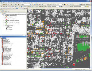
LiDAR data include information about the location of 3-D features that's often essential for complete geospatial analysis. With LiDAR data, geospatial imagery users can identify building footprints, trees, power poles, power lines and roadways with exact detail. The identification of 3-D features from within LiDAR data can be added as a vector or raster layer to an existingGIS, providing a third dimension for analysis. However, in geospatial analysis, feature identification may not provide all the information needed for a final product.

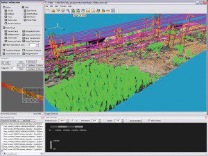
With LiDAR data, users can accurately identify and extract the location and height of power poles and power lines within a geographic area and apply that information to additional geospatial analysis.
When additional geospatial analysis is required, geospatial software uses the accurate elevation information and metadata within the LiDAR data to create more powerful end products and a more complete platform for decision making. Applying the information from LiDAR data to traditional geospatial processes, such as classification, feature extraction and change detection, adds critical depth to the analysis. For example, when building footprints extracted from LiDAR data are combined with traditional optical imagery, a user is able to perform geospatial analyses like feature extraction to produce end products that include accurate building elevation, roof slope and building size information.
The use of LiDAR data for geospatial analysis isn't limited to urban planning applications. LiDAR data also can provide an increased understanding of environmental monitoring.
When using traditional geospatial imagery and data to complete a forest inventory, there are often inaccuracies in the end product because geospatial imagery doesn't have the detail needed to identify individual trees within a forest. Traditional geospatial imagery is able to classify large swaths of tree cover and even determine the tree type within those areas; however, LiDAR data can accurately identify individual tree heights.
This ability to accurately identify individual tree heights among many is due to the capability of LiDAR sensors and data to see through leaves. Users conducting forest inventories will find that LiDAR data improve analysis through the accuracy of the feature elevation information and the eventual combination with existing geospatial data. When accurate location and classification information from LiDAR is added to aGISfor additional analysis, the end result is a forest inventory that contains accurate information about individual trees.
Leveraging Elevation Data
Geospatial information users aren't limited to using only 3-D feature information from LiDAR. Elevation information from LiDAR often provides a critical addition to geospatial analysis. By combining geographic and location meta-information from geospatial imagery with LiDAR data, geospatial analysis can be performed with confidence in the end product's accuracy.
By combining the elevation information from LiDAR with the location and land cover information from geospatial imagery, users can create a viewshed analysis that includes precise elevation and visibility information as well as critical information about a location's geography and land cover. And with the addition of LiDAR data to a geospatial viewshed analysis, users can feel confident in their elevation data's accuracy.
For utilities management, LiDAR data can provide accurate power line height and location information, as well as power pole location information. However, LiDAR data are limited in that they can't provide the information necessary to identify and classify the land use types that surround power poles and power lines. To create more complete and informative right-of-way studies, users will identify power poles and lines in their LiDAR data and export that information to be combined with geospatial imagery for further analysis.
Data Fusion Yields Exponential Benefits
Effective data fusion is essential to making the combination of LiDAR data and geospatial imagery accurate and useful.
Data fusion, in the simplest of terms, entails combining two or more data modalities that take advantage of the strengths of both types of data, leading to a more powerful analysis than what could be done with either data type alone. LiDAR data and geospatial imagery can be fused through a variety of software solutions that support both data types or, more commonly, support the exported vector or raster results of LiDAR analysis. The benefit of geospatial imagery fused with LiDAR data is the application of accurate elevation and 3-D features in traditional geospatial analyses and inclusion in aGIS.

When raster or vector layers are extracted from LiDAR and included in geospatial analysis, the detailed and accurate feature elevation and location information can be used for further analysis.
For geospatial imagery users, adding LiDAR data to their existing workflows and applications can provide accurate depth to their analysis. LiDAR data can't replace the information users can obtain from geospatial imagery; however, such data complement geospatial imagery by providing critical information regarding the identification and location of 3-D features and additional elevation information to make GISand mapping applications more accurate.


