Today's warfighters can collect, manage and deliver geospatial intelligence more effectively than ever. What's next?
By Pete McIntosh, solutions engineer, Exelis Visual Information Solutions (www.exelisvis.com), Boulder, Colo.
Geospatial imagery has supported defense and intelligence operations since World War I, when aerial photography changed the vantage point of the battlefield. The types and sheer volume of geospatial imagery have increased dramatically during the last 100 years. Today, images are acquired from sources that include satellites, spacecraft, manned aircraft, unmanned aircraft systems and even handheld devices, providing vast volumes of imagery that continue to expand exponentially.

Panchromatic imagery (left) is generally used when higher spatial resolution is needed for analysis. Multispectral imagery (center) captures light wavelengths that are visible and invisible to the human eye and is frequently used with panchromatic imagery. LiDAR data (right) provide detailed elevation information that helps create highly accurate 3-D products.
Geospatial Images as Far as the Eye Can See”and Beyond
Imagery has advanced dramatically from when aerial photographs were used for literal analysis. Today, spectral imaging divides the light spectrum into multiple bands that can detect wavelengths beyond the human eye's abilities. Multispectral images, which have been around since the 1970s, capture multiple wavelengths of electro-magnetic radiation. Images taken at different wavelengths can be combined to make an image composite that results in color patterns used to classify surface features, such as land cover and land use information, as well as to identify materials and vegetation through analysis. These types of analyses can be used to categorize terrain, allowing warfighters to know which terrain in an area is, or is not, suitable for convoy movement.
Hyperspectral images are similar to multispectral, but hyperspectral images break the light spectrum into numerous, narrow bands, allowing users to analyze subtle differences among dozens, or even hundreds, of spectral bands. While multispectral imagers capture surface reflectance over defined bandpasses, hyperspectral imagers capture surface reflectance at discrete, regular wavelengths, ultimately providing a richer source of information.
For example, while multispectral data can roughly characterize an area's geology, hyperspectral data can provide specific mineralogy for the area. Because hyperspectral scanning collects detailed information over a predefined portion of the light spectrum, it aids in surveillance and target analysis because specific objects have unique spectral signatures. Hidden or concealed targets, such as camouflaged enemy tanks or targets, can be detected by searching an image for statistical and spectral distinctions that differentiate the objects from the background landscape.
Traditionally, most geospatial information has come from 2-D imagery and data such as multispectral and hyperspectral imagery. However, defense and intelligence professionals increasingly use 3-D information sources, such as light detection and ranging (LiDAR) technology, to create realistic 3-D visualizations and extract 3-D features”trees, building footprints, power poles and power lines, etc. Geospatial products that are created with such information give soldiers the ability to better prepare themselves for potential obstacles during a mission.
LiDAR is a remote sensing technology that uses light pulses to measure the distance between a sensor and reflecting objects such as Earth's surface, buildings and trees. The result is a collection of data points called a point cloud, which is used to precisely render 3-D shapes and accurately locate features in a scene. The accuracy of LiDAR technology has made it possible to map large areas with levels of detail that previously were possible only with time-consuming, expensive and potentially dangerous ground surveys.

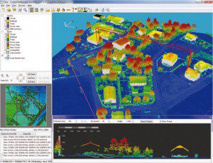
LiDAR analysis software, such as Exelis Visual Information Solutions' E3De, can create realistic 3-D visualizations and extract important features to enhance a warfighter's understanding of geospatial information. Here LiDAR data have been processed, and the software's cross-section viewer has been opened. The red rectangle in the main image window shows the extent of the cross-section results in that window.
LiDAR establishes the location and height of an object on the ground and is particularly useful when identifying transportation routes and understanding terrain before launching operations. Processing and exploiting LiDAR data is done with advanced LiDAR analysis software, such as Exelis Visual Information Solutions' E3De, to extract many sources of geospatial information like digital elevation models (DEMs), digital terrain models (DTMs), 3-D vector Information and more.
What to Do with All the Data?
Whether you work with panchromatic, multispectral or hyperspectral images”or LiDAR data”each data type offers unique information to support defense and intelligence operations. But the real power of these data types is tapped when fusing several of them together with advanced imaging analysis software, such as Exelis Visual Information Solutions' ENVI, which is designed to manage and exploit many types of geospatial data and to leverage the combined strength of different data types, providing the detailed information needed to make mission-critical decisions.
Data fusion can be as simple as pan-sharpening multispectral with panchromatic data or using multiple modalities together, such as LiDAR and multispectral imagery, to create rich, contextual surface models. Data fusion also includes taking a DEM of an area created in LiDAR analysis software and fusing the information with land classification results produced with imaging analysis software. Such fusion gives a clear picture of the travelability of an area by providing information like the grade of the land and the type of ground. This allows users to identify safe routes that are relatively flat with solid ground and avoid areas that have steep or marshy terrain, or loose ground combined with steep terrain.
Big Data No Longer a Big Deal
Advanced software tools that simplify routine tasks, rather than relying solely upon image analysts, has made geospatial imagery more accessible to more people. However, the job of managing the data has become challenging. File sizes and data volumes commonly push storage needs into terabytes as higher-resolution sensors push out ever-richer data sets. Along with the real cost of buying and maintaining hardware to manage this volume of data, there's inefficiency associated with moving huge data from system to system in a timely manner. The need to efficiently and cost-effectively manage big data has been a major driver in moving geospatial imagery to Web or cloud-based models (see Delivering Imagery on Demand from the Cloud).
In a cloud-based model, the data live on a host server and are accessed through a thin client like a Web browser or a mobile device. Data are accessed from the Web browser, but imagery analysis commands are passed to the server, where the processing occurs. This gives users the capability to quickly and easily identify, overlay and fuse georeferenced data from various sources to create maps or support geospatial analysis.
The use of a thin client with access to data living in the cloud, or on a server, allows users to search massive amounts of geospatial and intelligence data. This makes it simple to deploy centralized applications for data discovery, dissemination, and fusion of data and products.
While one advantage of a cloud-based model is centralizing and managing data from one place, the cloud also offers a collaborative work environment. Collaboration is easier in the cloud because work is saved on the host server rather than the desktop, allowing others to access and add to what already has been accomplished rather than duplicating efforts. Certainly the cost-saving benefit of using a cloud-delivery model for geospatial imagery is an attractive component, but the overwhelming advantage of implementing cloud-based analytics is the ability to deliver what people want, when they want it and where they need it most. For the defense and intelligence communities, that means delivering geospatial awareness to warfighters in theater.
From the Cloud to the Ground

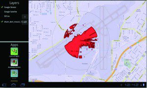
A screen capture shows an implementation of the cloud-based image analysis solution ENVI Services Engine. In this example, a mobile device was used to perform a line-of-sight analysis, with red areas indicating locations that can be seen from the center of the analysis area. This sort of on-demand analysis would be particularly useful to soldiers in theater who want to know how exposed their location is to the enemy.
Even over highly constrained bandwidths, warfighters must be able to access imagery information directly on mobile devices to gain situational awareness, identify safe routes in foreign territories or monitor enemy activity. Geospatial imagery and geographic information system (GIS) data can be fused with other types of intelligence such as signals intelligence, human intelligence or crowd-sourced intelligence. The near real-time fusion of these products produces faster, corroborated and more reliable geospatial intelligence.
For example, a warfighter preparing for operations in a remote area of Afghanistan has little geographical information available. He can access a geospatial server from his tablet in the field and run an analysis to look for lines of communication, identifying access routes into the area. If there are multiple data collections over time, he also has the option to run change detection to determine whether enemy equipment movement has moved into or out of the area. In addition, he can tap into recent chatter on social media sources that might provide the status of on-the-ground conditions.
Without such remote access, the warfighter would have to make a request to an analyst in the production cell to create a topographical map of the area. This could delay pertinent, real-time intelligence such as enemy troop or equipment movement, or the destruction of roads or bridges. Remote access to such functionality can reduce the time needed to acquire this critical information from days to hours. Accessing the complete picture, in real time, can be the difference between accurate intelligence and walking into an ambush.
Such information must be accessible, but the software tools used to generate the information must be integrated with popular platforms, scientifically accurate and interoperable with common data standards. With shrinking budgets, fewer personnel resources and even fewer experts to analyze the data, it's time for the defense and intelligence communities to pursue on-demand, online tools that offer reliable analysis on a variety of platforms.


