April 8 Webinar Announced
BERLIN, Germany, 18 March 2021 “ UP42 will offer automated geospatial processing analytics from CATALYST on the UP42 marketplace and developer platform. Available in March, the first offering will be the CATALYST InSAR processing block, which measures millimeter-scale ground deformation from time series Synthetic Aperture Radar (SAR) satellite data sets.
Introduced in 2020, CATALYST is a new brand from PCI Geomatics, the Canadian pioneer in remote sensing science and geospatial software development. CATALYST launched the CATALYST Insights suite to package its algorithms and analytics tools into integrated, customizable processes. Designed for both geospatial professionals and non-technical users, these analytics extract actionable information from image data and present results in readily understandable formats.
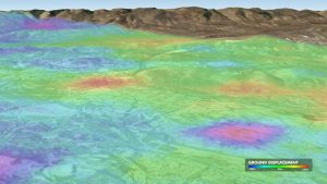
Sample ground deformation measured from Sentinel-1 time series InSAR data near Bakersfield, CA.
Our partnership with CATALYST will give UP42 users access to a range of powerful processing and analytics capabilities for satellite data, said UP42 CEO Sean Wiid. The initial InSAR processing block detects subtle terrain changes known as ground deformation. This has a range of vital applications related to monitoring critical infrastructure, tracking subsurface water levels, and predicting geohazards.
The UP42 platform offers extensive Earth observation data sets and advanced processing algorithms “ along with cloud computing power “ to create custom geospatial solutions easily and inexpensively. Users purchase just the data needed to cover their area of interest and then leverage off-the-shelf processing capabilities to analyze the datasets without investment in their own computing infrastructure.
We are very pleased to be partnering with UP42 to help us fulfill our goal of simplifying access to earth data. By deploying CATALYST algorithms on the cloud next to the earth observation imagery, we empower developers to access our proven science to build innovative applications for critical infrastructure monitoring, said CATALYST VP Product and Marketing Kevin Jones. We look forward to deploying more workflows and exposing more of our science through UP42, a geospatial market leader embracing cloud native platform development for information processing and delivery.
UP42 users will be able to apply the CATALYST InSAR analytics to Sentinel-1 satellite data available on the developer platform, as well as other SAR data sets in the future.
For land deformation detection, UP42 users will find the InSAR processing block is a valuable monitoring tool in protecting critical infrastructure by detecting small terrain changes before potentially catastrophic ground movement. InSAR measures subsidence” slumping and slope creep that pose risks to oil & gas wells, hydrocarbon pipelines, dams, mining sites, transportation corridors, and agriculture irrigation systems.
Webinar on April 8
Subject: Learn how to calculate velocity of ground movement with CATALYST’s InSAR Stack Workflow on UP42
Register: https://catalyst.earth/knowledgecenter/webinars-2-2/webinar-registration/
About UP42
UP42 is changing the way geospatial data is accessed and analyzed. The platform and marketplace bring together multiple sources of data such as satellite imagery, weather data, and more”together with algorithms to identify objects, detect change, and find patterns. Industry leaders use UP42 to inform business decisions and build scalable customer solutions. Know when and where to fertilize crops. Measure air quality and map emissions. Count cars, trucks, planes, and ships. Developers and data scientists across all industries now have access to a platform to build, run, and scale projects in one place. Visit www.up42.com.
UP42 Contact:
Nathan Davis
About CATALYST
CATALYST is a PCI Geomatics brand, which has been introduced to put our leading-edge technology into the hands of decision makers. CATALYST offers proven algorithms rooted in photogrammetry and remote sensing to offer engineers, environmental managers, and other professionals accessible earth data measurements on a reliable basis derived with leading edge, scalable software solutions and platforms.
