Reveal, the world’s leading underground utility data management company, is launching a new Data as a Service product called Underdots, which massively speeds up the analysis of ground penetrating radar data for utility locators.
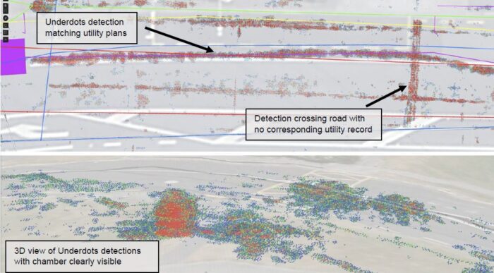
Underdots creates an intuitive, accessible point-cloud visualization from multi-channel GPR data in a matter of hours. Clustered dots plotted in 3D space show the intensity and depth of radar reflections, which can reveal the presence or absence of underground utilities in large areas:
Underdots is compatible with the most popular multi-channel ground-penetrating radar models from Kontur and IDS but should work with all 3D GPR arrays. Users upload raw GPR data from their units to the Underdots cloud service, and the data is automatically processed and added to a GIS project with a publicly available or customer-supplied elevation model applied.
Reveal CTO Tim Rastall says:
“Mass radar data collection tools have rapidly improved over the past 10 years, but interpretation and visualization of the raw radar data has remained expensive and time-consuming. Underdots leverages the fast cloud computational resources we have available to process raw radar data into a format that is useful and can provide immediate actionable insights for designers and consulting engineers at the design and planning phase of their projects.”
The key insights from Underdots are being able to compare the geophysical investigation data with existing utility plan information in a single environment.
Rastall says:
“The Underdots visualization is great for confirming the location of utilities, but more often we are finding evidence of utilities in areas where the plans say there shouldn’t be anything at all. Underdots can help prioritize the investigations budget for further invasive potholing or trenches, saving thousands of dollars in the process.”
Reveal has been trialing the use of Underdots with several major infrastructure projects in New Zealand and Australia using Reveal’s own data collection service, but Underdots is now available worldwide for any utility locator or contractor with a compatible radar.
Learn more about Underdots at www.underdots.com or watch the short video.
About Reveal
Reveal is Australasia’s leading utility locating technology company, with a staff of subsurface utility engineers, geophysicists and GIS analysts working together to provide insights into the subsurface for a range of major civil infrastructure clients and utility network owners.
Reveal’s technology platform brings together all sources of data on the underground, from existing utility plans to investigation evidence, aerial and LiDAR sensor information, to create Undermaps – the most accurate and comprehensive understanding of the subsurface environment.
