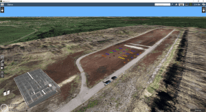
Riga, Latvia – SPH Engineering announces the official launch of its in-house drone flight area, enriched with a unique 450×70 meter range for various types of geophysical sensor testing with UAVs. The purpose-built testing ground features multiple targets of different materials and sizes buried in a variety of soil types.
SPH Engineering's test range is designed for manufacturers, surveying and scientific teams for equipment testing and various experiments. The four distinct seasons in Latvia provide the opportunity to test the technologies in a wide range of conditions: dry soil in summer, wet to extremely muddy in spring/autumn, and frozen in winter.
Dozens of real-life application scenarios for geological sensors were taken into account to design the testing area. There are 23 permanently installed targets (pipes, barrels, etc.) buried in natural soil (layers from sand to clay) to inspect. The coordinates of the targets are known with cm-level precision to ensure the highest possible accuracy when interpretating data acquired by the geophysical sensors. Also, the diagonal orientation of pipes makes it possible to test the target's responses at different depths and distances from the sensors.
We integrated the first sensor with a drone back in 2017. It was a GPR. The solution has been widely used, mainly for industrial and archeological surveys, as well as for fresh water bathymetry. The decision to create an innovative test range was in response to the unexpected increase in requests for various UAV integrations from potential customers and sensor producers during the pandemic in 2020. Within a year, we successfully integrated two magnetometers, an echo sounder, a new methane detector and a metal detector with a drone, Alexey Dobrovolskiy, CTO at SPH Engineering, explains.
Earlier this year, SPH Engineering renamed UgCS Industrial Solutions as UgCS Integrated Systems. The new name more accurately reflects the company's specially developed sensor+drone portfolio.
Learn more at https://integrated.ugcs.com/geophysical-drone-test-range
About SPH Engineering
SPH Engineering (sph-engineering.com) is a multiproduct drone software company and UAV integration services provider. Founded in 2013 in Latvia (EU) as a UAV mission planning and flight control start-up, the company has evolved from a developer of a single flagship product (UgCS) to a market leader of multiple drone solutions. Today, the company boasts a rich global customer and reseller network in 150+ countries, while over 45% of partners are located in North America. To provide high-quality solutions for UAV professionals, SPH Engineering's team advances four key product lines: UgCS (mission planning and flight control software), UgCS Integrated Systems (airborne integrated systems with sensors from diverse manufacturers), Drone Show Software (only commercially available software to manage drone swarm flights) and ATLAS (AI platform to process and analyze geospatial data).
