Spatial Manager version 6 (AutoCAD, BricsCAD, ZWCAD and Desktop) has just been released. You will find many improvements and new features in this version, such as the new Terrains commands. Update your application or download the free trial version here:
- Spatial Manager for AutoCAD (AutoCAD 2008 to 2020)
- Spatial Manager for BricsCAD (BricsCAD 13 to 20)
- Spatial Manager for ZWCAD (ZWCAD 2017 to 2020)
Main new features included in version 6 (Blog entry):
- Terrains (only CAD versions – Related video). As an extension of the dynamic Background Maps technology, now you can:
o Get 3D Points from elevation services in any region of the earth
o Create 2D or 3D contours from drawing points or elevation services
- Set the contours intervals
- Choose drawing styles for each type of contour
- Customize contour labels
- Build data tables attached to the contours
o Create 3D terrain models
- DTM / TIN surfaces
- Apply any dynamic Background Map texture (images) to terrains
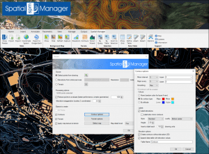
Terrain functions and Contour options
- Bing Background Maps: Eight new preset dynamic maps have been added (Dark, Gray, Light, etc.)
- Multi-Polygons: Polygonal elements can now be imported as Multi-Polygon entities (MPOLYGON) not only in AutoCAD but also in BricsCAD
- Labeling linear objects: New option to set the spacing between Labels when labeling in import processes
- WFS data stores: New native data provider for WFS, more comprehensive that the existing ones based on FDO or OGR
- Coordinate systems: EPSG tables (CRSs and other objects) have been updated to version 9.8.2
- and more
Import/export spatial or GIS data in Desktop or into/from AutoCAD, BricsCAD and ZWCAD, and experience the advanced tools to manage spatial data, such as terrains, dynamic background maps, quick drawing publishing in Google Earth, data structures and data grid, queries, layer thematics, automatic labeling, and many more
Note: Some features can only be found in the Standard or Professional editions. Some of them only apply to CAD versions and may not be available in older AutoCAD, BricsCAD or ZWCAD versions
