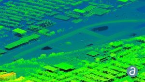
Montreal, Canada, December 3rd, 2019 “ SimActive Inc., a world-leading developer of photogrammetry software, announces a new LiDAR workflow integrated in its Correlator3Dâ„¢ product. The capability allows to import a point cloud in the software and to perform registration with an image dataset. Using LiDAR as control eliminates the need for traditional ground control points (GCPs) when processing the photos.
The registration occurs during aerial triangulation, leading to a precise alignment of imagery with the LiDAR data. Following this, Correlator3Dâ„¢ can output colorized point clouds as well as seamless orthomosaics.
Removing the need to manually tag GCPs facilitates the integration of LiDAR data with imagery, said Dr Philippe Simard, President of SimActive. Our clients can benefit from different data sources, with perfect co-registration.
About SimActive
SimActive is the developer of Correlator3Dâ„¢ software, a patented end-to-end photogrammetry solution for the generation of high-quality geospatial data from satellite and aerial imagery, including UAVs. Correlator3Dâ„¢ performs aerial triangulation (AT) and produces dense digital surface models (DSM), digital terrain models (DTM), point clouds, orthomosaics, 3D models and vectorized 3D features. Powered by GPU technology and multi-core CPUs, Correlator3Dâ„¢ ensures matchless processing speed to support rapid production of large datasets. SimActive has been selling Correlator3Dâ„¢ to leading mapping firms and government organizations around the world, offering cutting-edge photogrammetry software backed by exceptional customer support. For more information, visit www.simactive.com.
