Riga, Latvia РOne of the largest Ad̩lie penguin colonies in the world was surveyed with multiple-UAVs. Survey time was reduced from 3 days (with a single drone manually piloted) to under 3 hours. The work was led by a team of experts from Stanford University, Point Blue Conservation Science and Conservation Metrics.
UgCS software by SPH Engineering was used to develop a system to autonomously survey. Thousands of high-resolution images were taken on each survey and an AI model (Conservation Metrics) is under development that will automatically identify and count adult penguins and their chicks.
˜Using UgCS with a custom route planning algorithm (Stanford) our team efficiently photographed over 300,000 breeding pairs of penguins at Cape Crozier, Antarctica. Ultimately these surveys will contribute to large scale assessments of penguin populations and breeding success, key metrics for monitoring the health of the Antarctic marine ecosystem', Annie Schmidt, a researcher at Point Blue Conservation Science, explains.
The drone image was taken during a survey to count chicks (the gray, fluffy penguins) in mid-January, 2021 (© Point Blue).
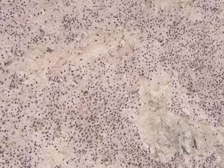
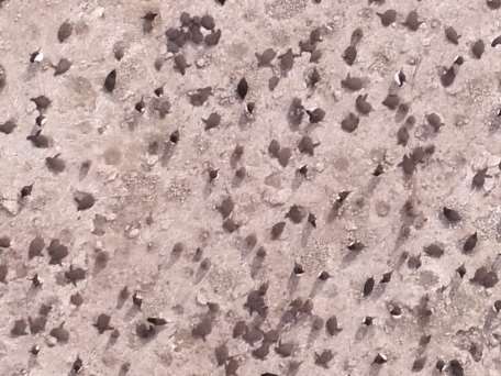
The first image shows the raw image from the drone and the second is zoomed in on the same
image to show the view when training the counting model.

A close up image of chicks from the ground taken just a few days before the survey (c) Annie Schmidt/Point Blue.
The research was funded by the National Science Foundation and carried out under Antarctic Conservation Act Permit #ACA 2020-005. A multi-drone imaging system was put to the test in Antarctica in 2020.
SPH Engineering supports penguin studies as a part of its global UgCS Educational program. In 2020 UgCS was used by over 250 universities globally in environmental, archeological, geophysical, engineering, agricultural, biological and many more areas of application.
About SPH Engineering
SPH Engineering (sph-engineering.com) is a multiproduct drone software company and UAV integration services provider. Founded in 2013 in Latvia (EU) as a UAV mission planning and flight control start-up, the company has evolved from a developer of a single flagship product
(UgCS) to a market leader of multiple drone solutions. Today, the company boasts a rich global customer and reseller network in 150+ countries, while over 45% of partners are located in North America. To provide high-quality solutions for UAV professionals, SPH Engineering's team advances four key product lines: UgCS (mission planning and flight control software), UgCS Integrated Systems (airborne integrated systems with sensors from diverse manufacturers), Drone Show Software (only commercially available software to manage drone swarm flights) and ATLAS (AI platform to process and analyze geospatial data).
