BERLIN, Germany “ AiDash, a leading satellite analytics company based in Santa Clara, Calif., has launched a predictive vegetation management product for utilities that leverages the UP42 Earth observation marketplace. AiDash's satellite-powered Intelligent Vegetation Management System (IVMS) has already reduced outages and slashed vegetation management costs for a Fortune 500 electric utility.
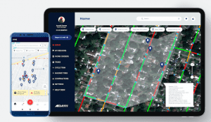
Screenshots of AiDash’s IVMS web dashboard and mobile app that use satellite data from UP42 to simplify vegetation management for utilities in the U.S.
Easy access to satellite data using UP42 formed the backbone of our IVMS solution, said AiDash CEO Abhishek Vinod Singh. The archive of historical high-resolution satellite imagery, which is hard to find elsewhere, is readily available from UP42.
Keeping vegetation trimmed near power distribution lines is an expensive and time-consuming “ yet critical “ task for electric utilities. Encroachment by bushes and trees can cause wide-spread outages and spark devastating wildfires. Energy utilities worldwide spend billions of dollars each year to continuously monitor vegetation in their powerline corridors from the ground and the sky, often using manned and unmanned aircraft.
The AiDash IVMS solution enables utilities to identify risks and plan vegetation management activities years in advance. AiDash has developed AI algorithms that analyze archived and current optical and synthetic aperture radar (SAR) images captured by satellites to predict vegetation growth rates. This analysis, delivered via a web dashboard and mobile app, allows the utility to focus its trimming operations in high-risk areas.
AiDash predicts when and where dangerous vegetation encroachment will occur so the problem can be addressed before an outage or wildfire takes place, said UP42 CEO Sean Wiid. IVMS is now being used to safely and cost-effectively monitor over 50,000 miles of distribution lines spanning multiple states for a U.S. utility.
The AiDash solution relies on the UP42 Earth observation marketplace to provide high-resolution optical satellite imagery from the Airbus Pléiades satellites. AiDash searches and orders archived satellite data and enters tasking orders for new acquisition via the UP42 API-based platform. Requested data sets are streamed directly into the AiDash processing workflow.
Tasking new image collections is a simple, straight-forward process, and images are delivered very quickly, said AiDash's Singh. UP42's customer support is there to help in every step along the way.
While AiDash strictly leverages the Earth observation data on the platform, UP42 makes available all the tools needed to develop geospatial workflows, applications and even commercial products. In addition to satellite, aerial, weather, and AIS maritime data, UP42 gives users direct access to more than 50 advanced geospatial processing algorithms and cloud computing power to create their own geospatial solutions easily and inexpensively.
We created UP42 to democratize access to Earth observation data so that anyone can extract valuable insights to solve global or local challenges, said UP42's Wiid.
For details on the AiDash IVMS solution, please read this utility case study on the UP42 website: https://up42.com/case-study/utility-vegetation-management-with-aidash
About UP42
UP42 is changing the way geospatial data is accessed and analyzed. The platform and marketplace bring multiple sources of data such as satellite imagery, weather data, and more”together with algorithms to identify objects, detect change, and find patterns. Industry leaders use UP42 to inform business decisions and build scalable customer solutions. Know when and where to fertilize crops. Measure air quality and map emissions. Count cars, trucks, planes, and ships. Developers and data scientists across all industries now have access to a platform to build, run, and scale projects in one place. Visit www.up42.com.
About AiDash
AiDash is an AI-first vertical SaaS company enabling satellite-powered operations & maintenance for utility, energy and other core industries with distributed assets. AiDash uses high-resolution, multispectral imagery and SAR data from the world's leading satellite constellations that are fed into its proprietary AI models to make timely predictions for operations and maintenance (O&M) activities. This is coupled with an app that enables prioritized completion and audit of these O&M activities. The company has offices in the San Francisco Bay Area, Washington D.C. Metropolitan Area and Bengaluru. Visit www.aidash.com
