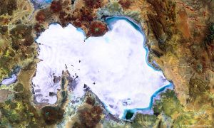
A false-color image of the Salar de Uyuni from the European Space Agency Proba-V satellite shows wavy patterns visible on the western side, while blue shades on the northern and eastern edges indicate flooded areas. The small rectangular patches to the south of the salt flat indicate a large lithium mining area. (Credit: ESA/Belspo “ produced by VITO)
Covering 10,500 square kilometers, Bolivia's Salar de Uyuni is the world's largest salt plain. Located in the highlands of southwestern Bolivia at an altitude of 3,650 meters, Salar de Uyuni is extremely flat, varying less than 1 meter across its expanse. It's so flat that it's often used to calibrate laser and radar altimeters on satellites.
The salt plains were formed 30,000-40,000 years ago as a result of transformations between several prehistoric lakes. The crusty top layer, several meters thick in places, lies on a brine rich in lithium (containing 50-70 percent of the world's reserves), potassium and magnesium.

