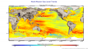
On average between 1993 and 2018, sea level has risen by 3.2 millimeters, but there are regional differences within this trend. This map is based on measurements from satellite altimeters and shows regional sea-level trends. (Credit: CNES/LEGOS/CLS/EU Copernicus Marine Service/contains modified Copernicus Sentinel data)
Scientists recently gathered in the Azores to share findings on how satellites have revealed changes in the height of the sea, ice, inland bodies of water and more. Of concern to all is the fact that global sea level has not only been rising steadily over the last 25 years, but recently it is rising at a much faster rate.
The 25 Years of Progress in Radar Altimetry Symposium gives participants the opportunity to share information gained from this particular sort of satellite instrument.
Radar altimeters record surface topography along the satellite's ground track. They precisely measure the height of water, land and ice by timing the interval between the transmission and reception of very short radar pulses.
This is the only technology that can measure, systematically and globally, changes in the height of the ocean”and is therefore essential for monitoring sea-level rise. The 25-year record of altimetry data allows scientists to determine trends.

