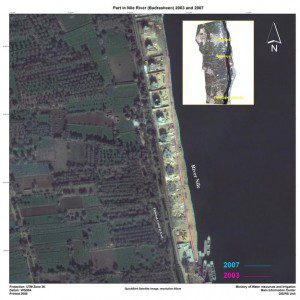
Egypt's Nile River is becoming thinner due to illegal building, which can pose a risk to agricultural activities downstream. Satellites are able to detect such changes with optical imagery.
The effects of climate change, population growth and economic development in the Mediterranean are posing a threat to the region's water supply.
As part of the European Space Agency's TIGER initiative, satellite data are supporting water management by identifying water resources. The demand for water is growing around the Mediterranean and is especially crucial in areas that don't receive regular rainfall. This is especially true for the southernmost parts of Europe and the countries lying along the African coast and in the eastern Mediterranean Basin.
Owing to the increasing population, the demand for water is growing for drinking and irrigation, representing 70“80 percent of the region's water use. To get a better grip on water management, satellites are increasingly acknowledged as indispensable tools for collecting information on available water resources and their use.
This information also is necessary for planning infrastructure, such as where to build a dam, how to divert a waterway or manage a flood event. The 10-year TIGER initiative exploits Earth observation technologies to respond to the urgent need for reliable water information in Africa.
TIGER currently is collaborating with the Euro-Mediterranean Information System on Know-How in the Water Sector, organizing water observation systems and building capacity in the Mediterranean region.
Image courtesy of Ministry of Water Resources and Irrigation, Egypt.
Read more about monitoring water resources in the Mediterranean.

