NASA satellites are providing valuable information about how wildfire smoke travels through the atmosphere.
Understanding how high wildfires send smoke into the atmosphere is key to predicting where and how a plume will spread. Smoke lofted above the boundary layer”the part of the atmosphere closest to the ground, where topography has a significant impact on winds”will spread farther than smoke that remains trapped near the surface.
Meteorologists closely monitor smoke plumes from wildfires because smoke can spread across vast distances and pose significant health hazards, particularly to children and the elderly. With numerous wildfires burning in North America in June 2013, there has been plenty to keep smoke-watchers busy.
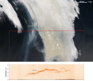
The accompanying images offer two views of smoke from a large wildfire that was burning in Quebec, Canada, in June 2013. Several satellites observed the smoke plume as it was moving east over Newfoundland toward the Atlantic Ocean.
The background (top) image was captured by NASA's Aqua satellite at 1:05 local time on June 23, 2013. It shows a true-color view of the smoke plume from above. The image has been rotated so that north is to the left; this is to line the image up with the north-south flight path (marked in red) of the CALIPSO satellite.
The lower image is based on data acquired at 1:14 p.m. local time by CALIPSO. The satellite's sensor sent pulses of laser light, know as light detection and ranging (LiDAR) technology, down through the atmosphere and recorded the reflections to generate a vertical profile of the smoke plume. The sensor detected smoke between about 2 and 6 kilometers (1.2 and 3.7 miles)”high enough that some of it was above the boundary layer. The height of the boundary layer varies, but it generally extends to a maximum of a few kilometers in eastern Canada.
Image courtesy of NASA.

