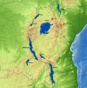
Getech experts are converting lake-surface satellite altimeter measurements to gravity information. The raw data are obtained from measurements collected by Cryosat-2 and Jason-1 satellites, which then are combined with GEOSAT data.
Getech developed a new satellite-based gravity data product that enhances explorationists' understanding of the East African Rift. Potential fields data have proved particularly successfully within this environment, and numerous oil companies have cited how such information had direct positive impacts on exploration campaigns.
Getech experts are creating these new datasets by converting lake-surface satellite altimeter measurements to gravity. The raw data were obtained from measurements collected by Cryosat-2 and Jason-1 satellites, which then were combined with previously acquired GEOSAT data. This unique combination of data and expertise created information of sufficient density to produce real insight for explorationists.
Getech created these advanced processing packages and linked onshore data for Lake Albert, Lake Edward, Lake Malawi, Lake Mweru, Lake Rukwa, Lake Tanganyika, Lake Turkana and Lake Victoria.
According to Simon Campbell, head of Gravity and Magnetic Solutions for Getech, translating our processing methods developed in open oceans to inland lakes has been a significant technical leap forward. This advancement, combined with the increased data density, has resulted in us providing complete coverage and insight over these inland lakes; an environment where we have seen potential fields play a key role in exploration.”

