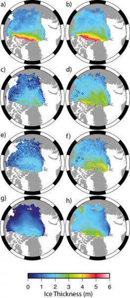
These images show ICESat, CryoSat and PIOMAS sea ice thickness measurements in the Arctic. Figure (a) shows the 2003“07 average ICESat ice thickness for October/November and (b) the 2004“2008 average for February/March. Figures (c) to (f) are measurements based on CryoSat data for October/November 2010 (c), February/March 2011 (d), October/November 2011 (e) and February/March 2012 (f). The final two figures are based on PIOMAS measurements for October/November 2011 (g) and February/March 2012 (h).
New measurements from the European Space Agency's ice mission validates that the volume of Arctic sea ice has declined by 36 percent during autumn and 9 percent during winter between 2003 and 2012.
Satellite records show a constant downward trend in the area covered by Arctic sea ice during all seasons, but particularly in summer. The past six years have seen the lowest summer ice extent in three decades, reaching the lowest last September at about 3.61 million square kilometers.
A team of scientists led by University College London has generated estimates of the sea-ice volume for the 2010“11 and 2011“12 winters over the Arctic basin using data from the European Space Agency's CryoSat satellite. The study confirms, for the first time, that the decline in sea ice coverage in the polar region has been accompanied by a substantial decline in ice volume. The new CryoSat dataset shows the volume's continuing decline observed from 2003 to 2008 by NASA's ICESat satellite.
Image courtesy of the European Space Agency/K. Giles et al.

