This natural-color satellite image was captured by LDCM's Operational Land Imager on March 30, 2013. The scene includes a dry lake bed in the Arizona desert known as Red Lake Playa.
You don't just launch a satellite into orbit and voilà , it takes measurements. Once in orbit, there are a series of check-out procedures to make sure it performs in space as it did in ground tests.

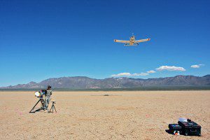
On the day the satellite image above was collected, researchers took measurements with instruments on the ground and from an airplane while LDCM took measurements from about 700 kilometers (500 miles) overhead.
You have to make sure the communication signals are strong and clear. You have to exercise moving parts like shutters and doors. You have to make sure the solar panels are oriented to the sun and batteries and thrusters are working properly.
For a satellite designed to take images”such as the new Landsat Data Continuity Mission (LDCM)”a critical step is calibration, both at the beginning of the mission and throughout its lifetime. There are many steps to calibration, but a key one is determining whether the observations of light and color reflected by Earth's surface match what can be observed with instruments and eyes on the ground. And since LDCM is the eighth satellite in a long line of Earth observers, calibration also involves matching new observations with how the previous satellites saw things.
Images courtesy of NASA.

