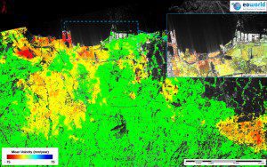
A map presents the natural hazard of terrain deformation from 2007 to 2010 over Indonesia's capital and largest city, Jakarta, and surrounding areas. In Jakarta Bay (highlighted by blue box) subsidence rates of more than 20 cm/year have been detected.
International experts will meet next month to discuss how space-based technology can help users prepare for, respond to and mitigate the risks of natural disasters. Natural hazards”like earthquakes and landslides”put people and places at risk every day, but satellites are able to help improve safety and mitigate these risks. Organized by the European Space Agency (ESA) in association with the Group on Earth Observations (GEO), the International Forum on Satellite Earth Observation for Geohazard Risk Management will be held May 21“23 at the Santorini Convention Centre in Greece.
The forum is open to geoscience users and experts working in the field of geo-hazard risk assessment and management. This includes representatives from space agencies and value-adding industries, as well as Earth observation mission owners/operators and users such as risk management authorities, land planning and risk prevention service providers and infrastructure managers.
Image courtesy of EO World; ALOS PALSAR data: JAXA; Cosmo-SkyMed data:ASI, e-GEOS.

