MIRAVI, short for MERIS Images RApid VIsualisation, tracks Envisat around the globe; generates images from the raw data collected by Envisat's optical instrument, MERIS; and provides them online within two hours.
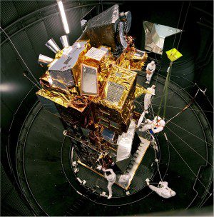
Launched in 2002, Envisat is the largest Earth observation spacecraft ever built. It carries 10 sophisticated optical and radar instruments to provide continuous observation and monitoring of Earth’s land, atmosphere, oceans and ice caps. Envisat data collectively provide a wealth of information on the workings of the Earth system, including insights into factors contributing to climate change.
Its largest single instrument, the Advanced Synthetic Aperture Radar (ASAR)”operating at C-band”ensures continuity of data afterERS-2. It features enhanced capability in terms of coverage, range of incidence angles, polarisation and modes of operation. The improvements allow radar beam elevation steerage and the selection of different swaths, 100 km or 400 km wide.
The Medium Resolution Imaging Spectrometer (MERIS) is a imaging spectrometer that measures the solar radiation reflected by Earth at a ground spatial resolution of 300 m, with 15 spectral bands in visible and near infrared and programmable in width and position. MERIS allows global coverage of Earth every three days.
The primary mission of MERIS is the measurement of sea colour in oceans and coastal areas. Knowledge of sea colour can be converted into a measurement of chlorophyll pigment concentration, suspended sediment concentration and aerosol loads over marine areas. It is also used for land and atmospheric monitoring.
Click here to visit the MIRAVI Web site.
Source: European Space Agency


