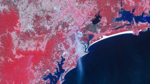
The UK-DMC2 satellite captured an image of Australia on Oct. 19, 2013. Burn scars can be seen in the charcoaled land to the right of the blaze. Agricultural land can be seen toward the middle of the image, while smoke marks the skies above Newcastle, just north of Sydney.
With more intense wildfire conditions predicted by experts, satellite imagery from the DMC constellation monitors fire damage and can assist planning for wildfire management.
According to reports, climate change and increased land development is leading to longer and more intense wildfire conditions around the globe. In Australia, with temperatures hitting 35°C and winds gusting 100km/h, this year's wildfires have been the worst in New South Wales in two decades. Fires have erupted across as many as 90 different sites, with 20 deemed out of control.
The Australian government has used DMC satellite imagery from UK-DMC2, supplied by DMCii , to help to inform their responses. The images mark out the various evacuation centers and show where fires are active.
Image courtesy of DMCii 2013 all rights reserved.

