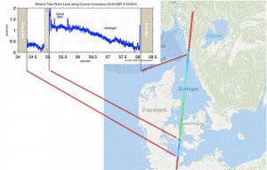
This image shows sea-surface height over the Kattegat Sea as measured by ESA's CryoSat satellite on Dec. 6, 2013.
The European Space Agency's CryoSat satellite measured the storm surge from the recent North Sea storms, as high waters passed through the Kattegat Sea between Denmark and Sweden.
The importance of realistic storm surge models was demonstrated recently by the devastation caused by Typhoon Haiyan in south Asia, where more than 5,900 people lost their lives in the Philippines alone. During Dec. 5-6, 2013, a major storm passed through northern Europe, causing flooding and blackouts; grounding flights; and bringing road, rail and sea travel to a halt.
Because the storm coincided with a period of high tides in the North Sea, there were extremely high sea levels”a storm surge. In the United Kingdom, sea levels were at their highest since the 1953 North Sea Floods; in Germany, parts of Hamburg were flooded.
On the evening of Dec. 6, CryoSat passed over Kattegat, providing an estimate of total water levels. The observations matched predictions, helping to confirm the models. The measurements were made by CryoSat's radar altimeter. Although the instrument was designed to measure sea-ice thickness, it provides outstanding results over sea, especially coastal areas.
Until recently, altimeter measurements of sea-level height could only be made over open oceans because of land interference closer to the coast. In the last few years, however, progress has been made to reduce these effects. This has allowed scientists to map water levels closer to the coast as well as profile land surfaces and inland water targets such as small lakes, rivers and their intricate tributaries.
Altimeter measurements from space can be used to validate storm surge models as well as provide near-real-time information that can be incorporated into predictions. Under ESA's Data User Element, the eSurge project is helping to optimize the use of altimetry and other types of satellite data to improve storm surge forecasting.
Image courtesy of ESA/NOC.

