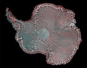
This RADARSAT-2 pole-to-coast Antarctic mosaic was created by MDA in cooperation with the Canadian Space Agency as part of the International Polar Year.
MDA Information Systems Group's new image of Antarctica, developed in coordination with the Canadian Space Agency for the International Polar Year (2007-08), is a unique compilation of more than 3,150 RADARSAT-2 images that comprise a single pole-to-coast map covering all of Antarctica. The mosaic provides a detailed representation of the Antarctic ice sheet showing subtle topographic features from the South Pole to the Antarctic coast line. Used in conjunction with the RADARSAT-1 Antarctic mosaic produced in 1997 by MDA, the RADARSAT-2 Antarctic mosaic provides a unique view of the approximately decadal change in the Antarctic ice sheets.
Operational users, scientists and researchers in climate change will derive significant value from the unique information presented in this Synthetic Aperture Radar (SAR) image mosaic. The image provides insight into the current condition of the Antarctic ice sheets, as well as the nature and rate of change in the Antarctic environment. In addition, the image provides a useful map to support operations needing detailed information to understand the surface and sub-surface features of the Antarctic ice. The knowledge gained from this important scientific mission will feed into the collective information being compiled worldwide on the Antarctic, providing a deeper understanding of the relationship between ice and climate change.
As part of the International Polar Year 2007-2008 (IPY), MDA Geospatial Services Inc., a subsidiary of MDA, in cooperation with the Canadian Space Agency, coordinated the acquisition of the data from Oct. 14, 2008 through Dec. 3, 2008. IPY marked a large international program of scientific research focused on the Arctic and Antarctic regions. For Canada, IPY provided an opportunity for a more complete scientific understanding of the North that could be applied to address issues related to Canada’s environment and the well-being of its communities.
This mosaic is complementary to the detailed glacier maps of the Antarctic provided by the University of California, Irvine, using RADARSAT-2 SAR data collected as part of the IPY initiative.
Launched in 2007, the RADARSAT-2 satellite is the result of a unique collaboration between MDA and the Canadian Space Agency. The satellite is Canadian designed, built and operated. This unique technology has been developed over many years in Canada starting with RADARSAT-1 and continuing with RADARSAT-2 and in the future with the RADARSAT Constellation Mission. The full continental coverage of Antarctica was made possible due to the unique capabilities of RADARSAT-2 to image left and capture data and information over the central part of the continent. This capability allowed the capture of data over the full land mass, from South Pole to coast”imagery that is at the heart of the discovery made by the University of California researchers. Canada is a world leader in space-based radar.
The satellite provides the follow-on to the RADARSAT-1 mission, serving data users around the world with new imaging modes, data with higher information content, and more responsive programming and delivery services. It directly supplies the growing global market for commercial high-resolution radar imagery in the maritime and land surveillance areas. RADARSAT-2's ability to collect imagery day or night, through clouds, fog and rain was critical to producing the mosaic.
MDA has played a leading role in the data acquisition and processing of the world’s two instances of pole-to-coast mapping of the Antarctic with SAR: RADARSAT-2 in 2008 and RADARSAT-1 in 1997. MDA is a leading provider of advanced monitoring, communications, and geospatial intelligence solutions that directly support Canadian Arctic sovereignty protection and intelligence. MDA’s leadership in real-time Arctic ice monitoring has been supporting Canada’s requirements for almost two decades.
Article courtesy of digitaljournal.com

