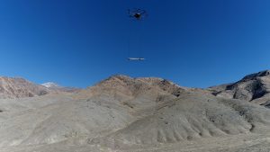
 Geophysics faculty and graduate students from the University of Nevada, Reno, are exploring blind geothermal systems using Unmanned Aerial Vehicle (UAV) magnetometry. The study site is located in the Humboldt Range, Nevada. By improving the margins of safety and ease of deployment, geophysicists can now conduct larger regional analysis for geothermal or mineralogical interests.
Geothermal power is produced in many regions throughout the world and is a source of green energy capable of providing baseload power 24/7. Nevada is well endowed with power-producing geothermal fluids that ascend to the surface along range-bounding extensional faults. Many of these geothermal systems are blind at the surface, showing no active geothermal features such as hot springs or fumaroles.
Magnetics surveying can reveal buried faults and boundaries of different rock types that provide clues to where geothermal fluid pathways are located. A ground magnetics surveyor can hike 15-20 kilometers per day on flat terrain. Much less can be covered in high-relief terrain that can put the ground operator at greater risk of injury during the days or weeks that it takes for a typical survey. In contrast, a two-person UAV magnetics crew can cover between 60-200 line-kilometers per day.

