West Java, Indonesia “ Terra Drone Indonesia, a group company of Terra Drone Corporation, one of the world's largest providers of industrial drone solutions, has successfully completed two pilot projects that demonstrate how construction companies can benefit from drone surveying and mapping services. Using drones equipped with Light Detection and Ranging (LiDAR) technology, Terra Drone Indonesia has carried out survey-grade topographic mapping for two different dam construction projects in the country.
Project 1: Bogor, West Java, Indonesia
In Bogor, the LiDAR drone technology was demonstrated to Wijaya Karya (Persero) Tbk, a construction engineering company working on a dam project in Megamendung. Covering an area of almost 20 hectares in a single day, Terra Drone Indonesia captured high-resolution data and images to generate an accurate topographic map and 3D model of the construction site. The data and images can now support decision-making in project controlling activities such as planning or measuring the work progress.
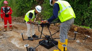
Terra LiDAR drone being prepared for flight
Project 2: Purworejo District, Central Java, Indonesia
In Purworejo, the survey activity was conducted for PT PP (Persero) Tbk, one of the main players in the national construction business in Indonesia. Over a period of 4 days, Terra Drone Indonesia carried out aerial LiDAR topographic mapping for a dam construction project in an area with dense vegetation to capture data and images for facilitating impeccable construction progress.
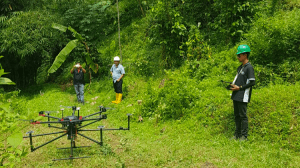
LiDAR drones make surveying easy in dense forests
Advantages of aerial LiDAR surveys in construction
In Indonesia, the sites of dam constructions are usually in watersheds or hilly areas. The slope of the terrain also varies greatly and the steep, rocky areas make direct terrestrial measurements difficult. Often, there are dense plantations and forests around the construction sites to make manual surveying extremely time-consuming and prone to errors. However, precise knowledge of the conditions and vegetation in the area around the construction site as well as information about the land surface is essential to determine the materials needed and to plan for the cut and fill activity, etc.
Using drones for aerial LiDAR surveys allows construction companies to obtain the information they require quickly and accurately, and enables them to adhere to their development plans. LiDAR drones can easily survey areas that are difficult to access for humans and simplify the process of construction project monitoring. The resulting data is beneficial for identifying any discrepancies between the initial plans and ground situations, empowering construction companies to control all aspects of the construction progress development.
Other application areas for aerial LiDAR surveys
Terra LiDAR, one of the latest drone innovations by Terra Drone Corporation, provides highly-detailed and accurate results at a cost which is two to three times cheaper than other similar technologies in the market. Besides construction, this technology can also be applied to activities in other sectors such as mining, oil and gas, plantations, and the utilities.
About Terra Drone Corporation
Terra Drone Corporation is the world's leading provider of industrial drone solutions established in 2016. The company's head office is located in Tokyo, Japan, with more than 25 branches globally throughout APAC, the European Union, Africa, and South America. Terra Drone provides innovative drone technologies empowered with LiDAR and photogrammetric surveying methods for construction, electricity, mining, energy, and oil and gas sectors. Terra Drone specializes in high-performance hardware, cutting-edge software, and service and drone management systems (UTM).
For our latest information, visit our LinkedIn and Twitter
