MipMap Technologies continues to provide GIS-based solutions to a long-standing client, Geotech Overseas of KSA, on their contract with the Municipality of Jeddah for a GIS project comprised of the collection of existing geospatial data, 3D topographic mapping and data conversion & integration on an area of approximately 2,400 km2. The works commenced in September 2020 and plans are in place for completion by September 2023. One of the most fundamental objectives of the project is to collect, classify and digitize the plans stored for decades in the archives of the Jeddah Municipality and their sub-municipalities.
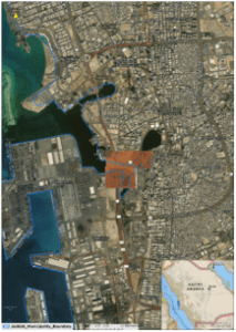
Mosaic Dataset composed of RS/500 Plans
Based on the contract , the client's 5 GIS needs were:
- Inventory and collecting division and organizational plans;
- Converting Paper Plans to Digital Plans;
- Designing a Geodatabase and Populating the Geospatial Data;
- Evaluating and Reviewing the Plans, and
- Geographical Monitoring.
ArcGIS in charge! MipMap and Geotech Overseas agreed to use the ArcGIS platform throughout the project to enter plan information, which prevented duplicate work and provided easy control of the progress. The geo-registration of the plans was also controlled from an ArcGIS dashboard. Any experienced user of ArcGIS would acknowledge that there are several ways to digitize raster plans in ArcGIS software packages and, among them, MipMap Technologies opted to use:
- Automatic Vectorization;
- Using the Vectorization Trace Tool and
- Interactive Vectorization since they all come in handy in creating clean and accurate vector data.
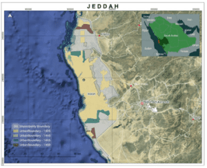
The Project Area of about 2400 km2
Apps-on-the-go! The ArcGIS Team effectively configured apps to manage the five tasks and deliver desirable solutions to the client. While one app helped operators enter plan information accurately and efficiently, another helped in tracking coordinates. A separate dashboard app was put in use to keep track of real-time progress in every aspect of project management. In short, the following ArcGIS Technologies were employed in this project with great results:
- ArcGIS Web AppBuilder for data entry application,
- ArcGIS Dashboards for monitoring project progress and
- ArcGIS Notebook for processing raster plans.
Already one year into the project, the team will eventually compare the CAD and GDB layers in the respective geodatabases to ensure that there are no missing layers. In order to keep the new database clean and consistent, the team will not migrate any unnecessary data into the new geodatabase.
About MipMap Technologies: An international company with over 40 years' experience in GIS technologies, MipMap is a platinum¯partner of Esri, the global leader in GIS technology. MipMap has an ongoing agreement with Esri to provide consultancy services until the end of¯2022 and has entered into R&D¯and project agreements with the Massachusetts Institute of Technology (MIT) and the World Bank. Leveraging a vast business experience in the¯Middle East, the Company's growth strategy now focuses on expanding business in Europe, Asia,¯and USA.
For more information and to stay up-to-date on latest news, visit www.mipmap.nl.
