Fugro has begun work on its first task order under a recently awarded multi-year hydrographic services contract with the US National Oceanic and Atmospheric Administration (NOAA). Located off the north-west coast of Florida, the project involves acquisition of high-resolution bathymetry data over four sites totalling approximately 1475 km2. Deliverables will be issued to NOAA by December and they will use this information to update charted depths and features in the region, many of which predate the 1950s.
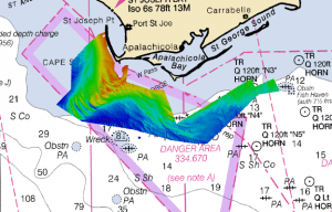
Fugro is returning to the north-west coast of Florida to perform hydrographic surveys for NOAA. The multibeam imagery shown here was collected during the 2018 and 2019 task orders.
To streamline the data collection, Fugro will deploy its new FAS-900 uncrewed surface vessel (USV) as a force multiplier on the project. The fit-for-purpose USV is equipped with multibeam echosounder technology and designed to increase the rate of data acquisition on medium- to large-scale mapping programmes. USVs reduce health and safety exposure and increase operational sustainability, all of which helps NOAA to achieve more efficient and effective nautical charting updates.
We are pleased to continue working with NOAA to update nautical charts in Florida using our own industry-leading technology, said Mark MacDonald, Hydrography Director for Fugro in the Americas. The company completed similar task orders in 2018 and 2019 under a previous hydrographic services contract with NOAA using crewed hydrographic survey vessels. Deploying the FAS-900 on this year's project will help ensure accurate and timely data collection ahead of peak hurricane season.
In addition to addressing concerns related to migrating shoals in the region, Fugro's 2020 task order will provide the first-ever comprehensive mapping in the western portion of the Big Bend Region, which is a priority of the Florida Coastal Mapping Program, a federal-state initiative to collect modern high-resolution bathymetry for all of Florida's coastal waters.
About Fugro
Fugro is the world's leading Geo-data specialist, collecting and analysing comprehensive information about the Earth and the structures built upon it. Adopting an integrated approach that incorporates acquisition and analysis of Geo-data and related advice, Fugro provides solutions. With expertise in site characterisation and asset integrity, clients are supported in the safe, sustainable and efficient design, construction and operation of their assets throughout the full lifecycle.
Employing approximately 10,000 talented people in 61 countries, Fugro serves clients around the globe, predominantly in the energy and infrastructure industries, both offshore and onshore. In 2019, revenue amounted to EUR¯1.6 billion. The company is listed on Euronext Amsterdam.
