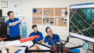
Montreal, Canada, September 18th, 2018 “ SimActive Inc., a world-leading developer of photogrammetry software, is proud to announce it enabled the first government drone mapping project in South Korea. Asia Aero Survey (AAS), a SimActive regional partner, used Correlator3Dâ„¢ for the public survey delivered to the Korean National Geographic Information Institute (NGII) and the Korean Association of Spatial Information, Surveying & Mapping (KASM).
While such projects were previously conducted using manned aircraft, a drone was preferred due to the difficulty in accessing the area of interest through traditional aerial and ground surveying methods. The NGII officially published guidelines for public surveying and mapping with drones in March 2018, with the AAS project being the first delivered and accepted as adhering to the new guidelines. AAS is also deploying UAV solutions with hyperspectral and LiDAR for other projects in conjunction with SimActive software.
About SimActive
SimActive is the developer of Correlator3Dâ„¢ software, a patented end-to-end photogrammetry solution for the generation of high-quality geospatial data from satellite and aerial imagery, including UAVs. Correlator3Dâ„¢ performs aerial triangulation (AT) and produces dense digital surface models (DSM), digital terrain models (DTM), point clouds, orthomosaics and vectorized 3D features. Powered by GPU technology and multi-core CPUs, Correlator3Dâ„¢ ensures matchless processing speed to support rapid production of large datasets. SimActive has been selling Correlator3Dâ„¢ to leading mapping firms and government organizations around the world, offering cutting-edge photogrammetry software backed by exceptional customer support. For more information, visit www.simactive.com.
