A growing number of local governments are discovering the value of remote sensing for fueling innovative applications and procuring grant funding. By Sudha Maheshwari, general manager, Sanborn (www.sanborn.com), Colorado Springs, Colo. Geographic information system...
NASA Partnerships Deliver Disaster Management Resources
The following guide highlights the broad range of Earth imagery and related geospatial products available from NASA and its mission partners to increase response efficiency and effectiveness. By Jennifer Brennan, NASA Earth Observing System Data and Information System...
Empowering Broad-Area Disaster Management
SAR complements LiDAR data to enable effective national-scale coverage for disaster planning and mitigation. By James Antifaev, MDA Geospatial Services (www.mdacorporation.com), Richmond, British Columbia, Canada. Changes in weather patterns around the globe are...
Maximizing Geospatial Workflows for Critical Applications
When it comes to humanitarian aid and disaster relief, effective collaboration and data integration can make the difference between life and death. By Rob Mott, vice president of Geospatial Solutions, and Andy Pursch, technical staff consultant, Intergraph Government...
DHS Embraces Remote Sensing
The U.S. Department of Homeland Security is implementing a dynamic environment to integrate and share Earth imagery. By Ron Langhelm, HLS GeoCONOPS Project lead, Booz Allen Hamilton (www.boozallen.com), Seattle. The homeland security community comprises a diverse set...
Does U.S. Policy Promote a Leadership Role in the Remote Sensing Satellite Industry?
Does U.S. Policy Promote a Leadership Role in the Remote Sensing Satellite Industry? By J. Christian Kessler, NorthRaven Consulting, Seattle. For decades, the United States led the world in building and operating remote sensing satellite systems. On cue with U.S....
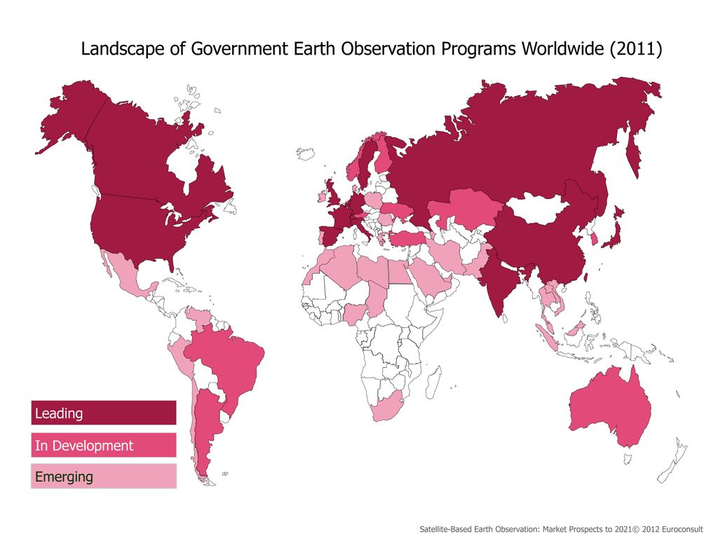
Emerging Markets Driving Long-Term Earth Observation Growth
Emerging Markets Driving Long-Term  Earth Observation Growth By Adam Keith, director, Space, Euroconsult (www.euroconsult-ec.com), Montreal. Growth can be seen at each level of the global Earth observation (EO) value chain, from manufacturing, launch and data to...
U.S. Environmental Intelligence Efforts Need Leadership
U.S. Environmental Intelligence  Efforts Need Leadership By Nancy Colleton, president, Institute for Global Environmental Strategies (http://strategies.org), Arlington, Va. There’s nothing like a 70-mph wind gust to get your attention. It seems like only...
Disaster Response Efforts Highlight the Value of Relationships
Disaster Response Efforts Highlight the Value of Relationships By M. Karen Walker, contractor, Office of Corporate Communications, National Geospatial-Intelligence Agency (www.nga.mil), Bethesda, Md. The U.S. response toHaiti’s January 2010 earthquake in...
High-Resolution Satellite Imagery”Can Funding Keep Pace With Technology?
High-Resolution Satellite Imagery— Can Funding Keep Pace With Technology? By Ian Dowman, professor emeritus, University College London, and author of High-Resolution Optical Satellite Imagery, available from Whittles Publishing (www.whittlespublishing.com) and in...
