Brussels, Belgium – From June 20th until June 22nd the pinnacle of the drone industry in Europe will gather at Commercial UAV Expo in Brussels. During this highly-anticipated conference and exhibition, an international jury of drone professionals will present...
Launch of INTERGEO 2017: Topics that Get the Geo-IT Sector Noticed
Berlin | 3, 2, 1 and lift-off. The 2017 INTERGEO season is underway, with a programme fully reflecting its long-standing key focus – “Knowledge and action for planet Earthâ€. Once again in 2017, the leading international trade fair for geodesy, geoinformation and...
The Getech Group Delivers Insights into African Lakes from Space
Getech, providers of natural resources exploration data and information expertise, has recently developed a new gravity data product that will enhance explorationists’ understanding of the East African Rift.  Potential fields data have proved particularly...
Diversified Communications Announces SPAR 3D Expo & Conference and AEC Science & Technology Event will Co-Locate in 2018 in Anaheim, Calif.
March 2017 (Portland, Maine, USA) – Diversified Communications, organizer of SPAR 3D Expo & Conference, International LiDAR Mapping Forum, Commercial UAV Expo Americas, and Commercial UAV Expo Europe announced today that SPAR 3D Expo & Conference will...
GEO Business 2017 Launches its FREE to Attend Workshops Demonstrating Cutting Edge Technology from Across the Globe
GEO Business – the leading international showcase for the geospatial industry, has unveiled its cutting edge commercial workshop programme for 2017. Featuring more than 80 workshops from 200 international exhibitors, GEO Business is expected to attract over 3,000...
GEO Jobe Welcomes Ken Doman to Role as Senior Front-End Engineer
NASHVILLE, Tenn. - GEO Jobe (www.geo-jobe.com) a leading GIS software and geospatial solutions provider and developers of Admin Tools, Mapfolio, and the GEOpowered cloud for ArcGIS, is pleased to welcome industry veteran, Ken Doman to the team in the role as Front-End...
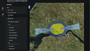
No Obstacles for Airports Using Satellites
Thanks to the European Space Agency (ESA), airports now can use satellites to identify and manage obstacles that could pose a risk to flight safety.
Cadcorp SIS Service Release Brings Extensive Support to Latest Ordnance Survey Products
Cadcorp has launched a new Network Manager application in the latest service release of Cadcorp SIS 8.0. The application loads OS MasterMap Highways Network data into a structured topological network that includes roads, paths, and asset management information. This...
Commercial UAV Expo Europe Announces Early Exhibitors and Other Backers
Portland, Maine, USA –  Commercial UAV Expo Europe, the highly anticipated exhibition and conference focused on UAS integration for large enterprise industrial applications, has just opened for sales and already these market leading providers have signed on to...
Black Swift Technologies Summits Extreme Altitude Mapping Test of Mount Evans (14,265′) with Small Unmanned Aircraft System (sUAS)
Boulder, CO – (March 14, 2017) – Overcoming the challenges of mapping terrain in difficult conditions at altitudes exceeding 14,000 feet using a small unmanned aircraft system (sUAS), Black Swift Technologies (BST), a specialized engineering firm based in Boulder,...
