HERNDON, Va.- Radiant Solutions, the newly formed geospatial services business unit of Maxar Technologies (formerly MacDonald, Dettwiler and Associates Ltd.) (NYSE: MAXR; TSX: MAXR) today announced its strategy for combining its legacy businesses to create a new...
Nearmap Releases Panorama and Oblique Aerial Imagery Inside New MapBrowser Interface
SOUTH JORDAN, Utah - Nearmap, a location content provider specializing in high-resolution aerial maps, announces the release of new forms of location content—Nearmap Panorama and Nearmap Oblique—available through a new MapBrowser™ interface. Nearmap has long...
Huawei and Hexagon Geospatial Showcase Geospatial Solutions at Smart City Expo World Congress 2017
BARCELONA, Spain, Nov. 14, 2017 - Hexagon Geospatial is proud to announce that we will partner with Huawei to showcase Smart City solutions at Smart City Expo World Congress in Barcelona, 14-16 November. Huawei, a leader in the Information and Communications...
Boundless Releases Server Product to Offer Complete Ecosystem of Enterprise GIS Solutions
St. Louis, MO – Nov. 14, 2017 – Boundless, the leader in open GIS for the enterprise, today announced the next iteration of its GIS software, Boundless Server. The company also announced that it has rebranded its flagship product, Boundless Suite, as Boundless...
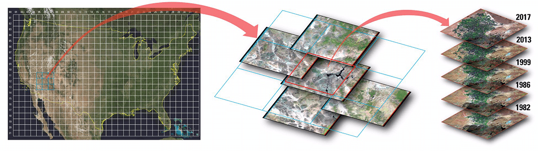
USGS Releases Landsat Analysis Ready Data
Improvements to the quality and usability of Landsat satellite data have been made with the release of a new USGS product called Landsat Analysis Ready Data (ARD), which will help reduce the time needed to process and analyze data and imagery, a significant advantage to scientists studying landscape changes, including changes from wildfires, hurricanes, vegetation cover, drought and other events.
Sefton Council Uses GIS to Support ˜One Council' Policy
One of the roles of the technical services team at Sefton Council is to support the Planning & Building Control department. This ranges from managing data used by planning officers on a day-today basis to producing evidence based work to assist the policy team....
The Sky Guys Selected to Develop Artificial Intelligence-Enabled Drone for Highway Monitoring
TORONTO- The Sky Guys, Canada’s leader in drone technology and unmanned solutions, have teamed up with NVIDIA, IBM and University of Toronto to be awarded $750,000, from Ontario Centres of Excellence (OCE), as part of the Small Business Innovation Challenge (SBIC)....
Esri Provides Mapping Technology for Students to Assess Hurricane Damage
REDLANDS, Calif. -Esri, the world leader in spatial analytics, today announced it is providing its ArcGIS platform, along with high-resolution imagery from the Vexcel Corporation, to students so they can use it to identify and assess buildings in Puerto Rico that were...
Surveying All New Territories – Martin Instrument Expands to Oklahoma
AUSTIN, Texas - Martin Instrument, the premier, authorized Trimble dealer of survey and construction equipment in Texas, has expanded to all of Oklahoma. "The Martin Instrument team has worked really hard over the past several years taking care of our customers and we...
USSOCOM Awards Vricon Foreign Comparative Test Contract
McLean, Virginia - The US Special Operations Command (USSOCOM) awarded Vricon a contract for a Foreign Comparative Test for commercial data, software, and testing to increase the resolution and accuracy of the Command’s 3D geospatial data. Vricon also will...
