The European Space Agency (ESA) has helped coastal authorities track up to 70 percent more ships and pick up nearly three times more ship positions via satellite than previously possible.
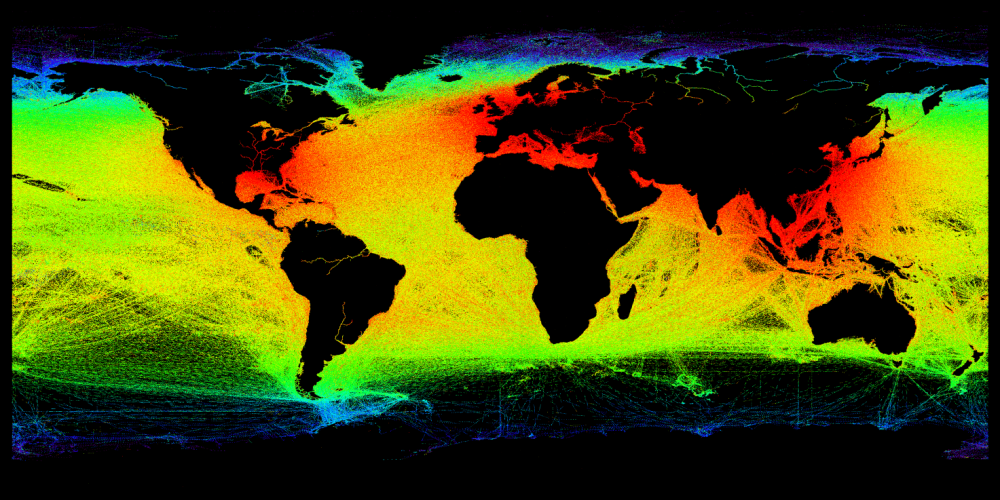
The European Space Agency (ESA) has helped coastal authorities track up to 70 percent more ships and pick up nearly three times more ship positions via satellite than previously possible.
WSP, the global company providing management and consultancy services to the built and natural environment, is using a range of remotely sensed data from Bluesky to aid existing analysis and develop new techniques. Using the Bluesky data, including laser mapped 3D...
URISA is thrilled to partner with the California Geographic Information Association (CGIA) and the four California URISA Chapters - SoCal, NorCal, CentralCal and BAAMA/BayGEO - to present GIS-Pro & CalGIS 2018 in Palm Springs this year! Those five...
HUNTINGTON BEACH, Calif. & AUCKLAND, New Zealand - Rocket Lab has successfully reached orbit with the test flight of its second Electron orbital launch vehicle, Still Testing. Electron lifted-off at 14:43 NZDT from Rocket Lab Launch Complex 1 on the MÄhia...
RICHMOND, BC - MDA, a Maxar Technologies company (formerly MacDonald, Dettwiler and Associates Ltd.), (NYSE: MAXR; TSX: MAXR), today announced that it has been awarded a contract by Public Service Procurement Canada on behalf of the Defence Research and Development...
ROME, N.Y. - The ASPRS and Microdrones Workshop Day will take place February 8th, in the Hyatt Regency Denver at the Colorado Convention Center, 650 15th St, Denver, CO 80202, the same hotel hosting the ILMF and ASPRS conference. Each workshop will have a $100 fee...
REDLANDS, Calif.— Esri, the global leader in spatial analytics, today published The GIS 20: Essential Skills, Third Edition, a book designed to quickly prepare those who need to use a geographic information system (GIS). The GIS 20 is aimed at readers who are new to...
SAN DIEGO – General Atomics Aeronautical Systems, Inc. (GA-ASI) successfully demonstrated its latest Automatic Takeoff and Landing Capability (ATLC) using a Satellite Communications (SATCOM) data link for its MQ-9B SkyGuardian™/SeaGuardian Remotely Piloted...
Shanghai - Tersus GNSS Inc. (“Tersusâ€), a leading GNSS RTK solution provider, announced today that it has launched BX306Z GNSS RTK board with powerful flexibility and compatibility to meet or exceed the needs of OEMs and system integrators. As a new member of the...
WASHINGTON - Anne Hale Miglarese, Radiant.Earth Founder and CEO, was presented with the prestigious Geospatial World Woman of the Year Award on January 17, 2018, at the Geospatial World Forum in Hyderabad, India. Ms. Miglarese received the award in recognition of her...
